It is incredible to me that Stockholm spent several decades in the mid-1800’s dithering about the need for city planning. This, in a city that had been dedicatedly building according to the same city plan for over two hundred years. This, in a city that was literally wallowing in its own feces. But despite its history of planning and the deadly epidemics, many city authorities considered planning too expensive, too inconvenient, too invasive, too socialist, and entirely unnecessary.
Outgrowing the Original Plan
First, a little background information on Stockholm’s first urban plan: Örnehufvud/Torstensson’s plan was drawn up in 1636 and the initial regularization was implemented over a couple of decades. After the plan was implemented, all new development (within the planned area) was built according to this grid plan. Throughout the 1700’s and the first half of the 19th century, Stockholm grew incredibly slowly and the city didn’t begin to outgrow the original plan until the 1800’s.
 |
| Approximate extents of Örnehufvud/Torstensson’s plan from 1636 |
Most new development outside of the original plan just extended the same grid pattern, so most of Stockholm’s building activity was still a relatively organized affair. The problem wasn’t orderliness so much as overpopulation: extending city streets that were sized according to the needs of a small city in the 1600’s didn’t translate well to a medium-sized city in the 1800’s. The streets were narrow and clogged with traffic.
 |
| This map from 1836 shows, in grey, how much of Stockholm had been built up. In red, the approximate area covered by Örnehufvud/Torstensson’splan from 1636. In essence, all of the blocks outside of the red outlines represent Stockholm's growth over 200 years. * |
Not only the streets were full to bursting, but the buildings themselves were over capacity. While the city’s building stock had hardly grown at all from 1800-1840, it grew from a population of 84,160 in 1840 to 100,000 in 1856 and 126,200 in 1865. Most of the newcomers were of the working class and couldn’t afford much in the way of housing. At the time, small buildings with relatively cheap rents were being razed to make way for larger, fancier buildings with higher rent. So while the population was expanding, the selection of housing available to the newcomers was actually shrinking. The result was severe overcrowding as several families crammed into a single room in order to meet the rent.
The other major problem was health. In the mid 1800’s, Stockholm had no water or sewage treatment and was one of Europe’s deadliest cities—the water sources were polluted and abundant swampy areas were breeding grounds for disease. Epidemics were common and more people died each year in Stockholm than were born. A third of all infants died in their first year. The only factor keeping Stockholm’s population somewhat stable was a constant stream of immigration from the countryside to the city.
Politics
There were three major factors contributing to the stagnation of Stockholm’s development. The first factor seems to be a simple matter of laziness and dogma—the city authorities adopted a laissez-faire attitude toward the city and they were extremely reluctant to interfere. This laissez-faire attitude was largely a matter of class politics—the wealthier classes could afford to import clean drinking water from the countryside and to escape to their country retreats during the deadly summer epidemics. The city’s poorer inhabitants suffered more from the city’s health and overcrowding issues, but the city authorities didn’t really care—the poor, working-class population was seen as disposable and replaceable.
Even when city authorities did admit a need for action, the rhetoric was often focused on the choked traffic and the need to create a better traffic flow to enable better business opportunities. Others emphasized the danger of the ramshackle neighborhoods as the breeding ground of socialism. In short, unhindered commerce was a much more important driver for change than the health of the poor.
The second major factor contributing to stagnation was money: Due to Sweden’s constant state of near-bankruptcy since the early 1700’s, very little had been built or developed in the city for 150 years. The third factor was city administration: Before 1862, the royal seat was directly under the control and financing of the cash-strapped monarchy. But in 1862, the city was finally granted the power to control its own fate and both the administration of the city and the city’s tax base were turned over to a new, modernized city government complete with salaried, full-time employees. While the whims of the monarchy still played a defining role in the city’s development, the city now had the mandate, the formal power, and some funding to act on its own.
There is an important asterisk to the city’s new self-governance. While the new city government was mostly democratically elected, the King still had the right to appoint a representative to the city council.
Early Calls for Planning
Since the worst conditions were to be found in Gamla Stan, the earliest proposals were focused on Stockholm’s Old Town. I have covered these proposals in depth in my post “Threats to Stockholm’s Old Town, Gamla Stan.” The most famous proposal was Rudberg’s plan from 1862 which proposed to raze all of the Old Town to make way for a new, orderly grid development. Although the proposal seems preposterous today, it was warmly received and the only thing stopping the city was money: expropriating all of the land and all of the buildings of Gamla Stan in order to redevelop it was just too daunting and expensive.
 |
| Rudberg’s plan from 1862 to rebuild the Old Town. ** |
There were a lot of factors and new technologies at work during this time period. There was an acute need for clean water and sewage treatment. The railroad was moving in. Regular public transportation following set routes and timetables in the form of horse-drawn trams was being introduced. Sturdier quays were needed to anchor larger and larger ships. There was a severe housing shortage. Yet all of these challenges were being solved, one by one, and no one was looking at the bigger picture. No one was thinking about how certain solutions could benefit more than one problem at a time. (Water and sewage pipes weren’t even laid simultaneously.) Problems were being solved for a very short time horizon and no one was thinking long-term. The city was systematically choosing the smallest and cheapest action possible.
The first person to suggest a more holistic study of the city was A.E. Schuldheis in 1857. His motion to the city council called for “a project plan for Stockholm City’s future appearance . . . not in respect to architecture but in respect to city planning.” He understood that this plan would benefit future generations more than those currently living: “We should act like farmers who plant oaks not to rest in the shade of the oak’s branches themselves but to leave it to our children and progeny to reap the fruits of our efforts.” One of his most powerful arguments was that tourists would be coming in on the railroad and that the city should offer them a reason to come: tourists do not flock to ugly cities. Schuldheis’s most concrete suggestion was that all of Stockholm’s waterfront should be lined with grand public walkways.
At the time, this last comment was so unlikely and utopian that he was practically laughed out of the council chamber, but the idea found some support. In the end, the council voted to form a committee to investigate the possibility of a more holistic city plan. In 1859, the committee’s formal opinion was that a more holistic city plan should, in fact, be created. The committee understood that given current legislation, the plan couldn’t be binding, but that it would help the city to make more informed decisions about infrastructure and such. The committee recommended that the plan should include:
1) the entire waterfront should be made public and developed into engineered quays
2) all existing streets and public spaces should be straightened out to match the city’s grid pattern
3) proposals for future streets and public spaces according to the grid
4) proposals for better air circulation, more trees, public urinals, and other measures for the city’s health
5) a deadline for when the above measures should be complete.
The committee’s proposal for a proposal wasn’t heard by the city council until 1860, and it was voted down. The time wasn’t considered ripe, especially because there was no up-to-date city map on which a new urban plan could be based. So instead of an urban plan, the city council ordered that a new city map should be drawn up. By 1862, no progress on a new map had been made.
The King Steps In
There had been at least three recent instances when the King had become tired of the City Council’s dithering stinginess, set his royal foot down, and made a decree that spurred the city to action. The first was in 1821 when the King decreed that the smelly fishing harbor at Strömparterren on Helgandsholmen should be removed and that a park should be planted instead. Then, in 1837, the King insisted that instead of a new bridge over the stinking, unhealthy bay at Nybroviken, the swampy inner areas of the bay should be filled in and made into a park and that a stone quay should be built at the water’s new edge. In 1861, the city council had rejected a proposal for a new quay and grand boulevard heading eastward from the city center. The King ordered the city to proceed with the project that is now Strandvägen.
 |
| Strandvägens quay and boulevard |
I don’t actually have a source that says outright that the King stepped in on Stockholm’s dithering about a new urban plan. Unlike with Strömparterren, Nybroviken, and Strandvägen, there was no royal decree that forced the city council into action. Instead, in 1862 the King appointed a new royal representative (Överståthållare) to the city council. The day after his appointment, Gillis Bildt (a somewhat conservative noble and a military officer) forced the hand of the city and work on a new city map was begun.
Bildt’s Motion for a Plan
In 1863, Bildt took further action. He realized that the need for a new urban plan was so urgent that the city simply could not wait for a fully updated map which would of course be somewhat outdated before it was even finished. Instead, an existing map from the 1840’s would suffice. Bildt understood that so drastic an action would never pass by the new, democratically elected council unchallenged, so he phrased his “decree” as a “motion.”
By the 1860’s, Stockholm’s population was exploding and new areas were being developed every day. Bildt defended the need for an urban plan writing that “there are still countless empty spaces in the city’s outer areas that will soon be developed.” Therefore there was an urgent need for a “comprehensive, pre-determined plan that would be followed in the future.”
Bildt’s motion for a comprehensive urban plan included several more general and several very specific requirements:
1) Sufficient and appropriate traffic routes from the periphery to the center of the city
 |
| Today's Sveavägen was eventually a direct result of Bildt's decree. |
2) Sufficient and appropriate cross-streets
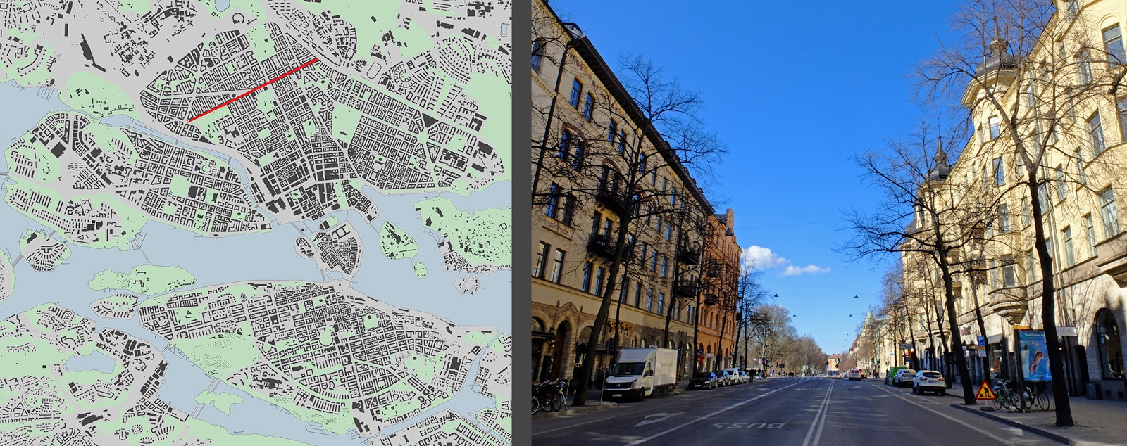 |
| Today's Odengatan was eventually a direct result of Bildt's decree. |
3) Quays at all waterfronts
 |
| Today's stone quays were eventually a direct result of Bildt's decree. |
4) The continuation and widening of existing streets, especially Klara Västra Kyrkogatan, Klara Norra Kyrkogatan, and Vasagatan which Bildt proposed would become the main arteries into Norrmalm from Gamla Stan.
 |
| Klara Västra Kyrkogatan and Klara Norra Kyrkogatan were never developed into main arteries. The 1700's meet the 2000's on Klara Västra Kyrkogatan. |
 |
| The southern end of Klara Norra Kyrkogatan did eventually get widened, but not until the 1960's. The northern end retains it's pre-industrial scale. |
 |
| While Klara Västra Kyrkogatan and Klara Norra Kyrkogatan were never developed into main arteries, Vasagatan was. However, it was never extended much past the city of the 1600's. |
5) A new food market at the new train station in Norrmalm
6) A new street on the eastern side of Humlegården which would provide a route out of the city to the north to the natural areas of Norra Djurgården (this street would become Sturegatan)
 |
| Today's Sturegatan was eventually a direct result of Bildt's decree. |
7) A new street to replace Träskrännilen, the very polluted creek running down into the bay at Nybroviken (this street would become Birger Jarlsgatan)
 |
| Today's Birger Jarlsgatan was eventually a direct result of Bildt's decree. |
8) New streets and public spaces in the Fatburen area where the lake had been filled in for the new railroad station.
 |
| It took about 100 years longer than the above street examples, but Fatburen park was eventually established in the old lake bed. |
9) Due to expropriation and financing difficulties, Gamla Stan should regretfully be excluded from the plan
10) Because the city’s civil servants were already overwhelmed with their own work, the city council should appoint a special task force
I am curious about how Bildt’s list of requirements was formulated. Was it given to Bildt from the King? Or did Bildt write the list? Was Bildt well traveled or well read on matters of city planning? Did he consult an engineer or an architect? It is said that Bildt wished to be Stockholm’s Haussman, but had he ever even been to Paris?
Aside from the more general requirements, Bildt more-or-less ignored Södermalm and entirely ignored Kungsholmen; Norrmalm and Östermalm were at the forefront of his list. This is probably partly due to the fact that the new central railroad station was slated to be located in Norrmalm, making that area the new central area of the city. Bourgeoisie commerce was already more centered in Norrmalm than on Södermalm. Also, Södermalm’s topography with its sheer cliffs facing toward the city were always a challenge, and aside from a few steep, long staircases and a couple of unreasonably steep streets, no one had yet proposed a good way to connect Södermalm to the rest of the city. Since both Södermalm and Kungsholmen were the poorer areas of town, Bildt was probably less interested in those areas, anyway.
The council agreed to Bildt’s motion and the City Engineer A. W. Wallström was asked to create a proposal and cost estimate in consultation with Rudberg “who has created a commendable plan for [Gamla Stan].”
The city was more or less forced into agreeing to create a new urban plan. Bildt’s less-than-democratic approach would later partly backfire, but the ball had none-the-less started rolling and there was no more denying the need for a new urban plan. Furthermore, the majority of Bildt’s plan requirements would eventually be worked into the new, comprehensive city plan, and they would even eventually get built. More on Walström and Rudberg’s plan in my next post...
Sources
Gösta Selling, Esplanadsystemet och Albert Lindhagen: Stadsplanering i Stockholm åren 1857-1887 (1970)
Per Kallstenius, Minne och vision: Stockholms stadsutveckling i dåtid, nutid och framtid (2010)
Images
All images are my own unless marked with
* underlying map: https://stockholmskallan.stockholm.se/post/9160
** Gösta Selling, Hur Gamla stan överlevde (1973)
No comments:
Post a Comment