
Östermalm, or “The Eastern Area,” was rapidly developed in the mid to late 1800’s. Developers were demanding to build, but the city of Stockholm, in all of its hemming and hawing first about the need for a city plan at all and later about what that plan should look like, was not prepared. Even after the Lindhagen committee presented their comprehensive and well thought-out plan, there was no consensus among city council members—many thought that Lindhagen’s plan was too ambitious and expensive. It would take 15 more years of meetings, proposals, and counter-proposals until the city could come to a consensus on and begin to implement a comprehensive plan.

In the mean time, while the city council remained deadlocked about a plan for the city’s future growth, Stockholm was in the middle of its most intense period of population growth, ever. In the 1880’s alone, the city’s population grew by 46% as migrants flooded in from the countryside. The population boom of course resulted in a severe housing shortage—the city was literally surrounded by vast tent encampments and ramshackle slums and inside the city, workers crowded into tiny apartments. It was not uncommon for a family of eight or for eight random adults to share a single room. Crowding into small apartments was the only way to get to sleep under a roof. Living conditions in Stockholm were nearly the worst in Europe, second only to Finland.
At this time, the banking industry was growing out of its infancy. A number of banking institutions were established and for the first time, one could loan money to buy and develop real estate. The group of potential investors grew enormously—before only the wealthy with ready cash in hand could buy and develop real estate, but now, just about anyone with a modest down payment could join in on the speculation. Between the housing crisis and the new availability of mortgages, speculation on land and real estate became rampant. During the 1880’s, 10% of Stockholm’s entire building stock changed hands every year. Real estate developers were practically day trading lots and rental buildings, causing the price of land as well as rents to skyrocket. Living conditions of course grew even worse as buildings frequently changed hands and their owners had little interest in upkeep, and as rents steadily rose.
The Eastern edge of the city, Östermalm, was at the helm of this speculation and development. Following in the footsteps of those who had moved to Strandvägen, Stockholm’s Park Avenue, it was here that the nouveau riche wanted to settle. Spacious apartments along the street were occupied by the wealthy, but the darker courtyard buildings were crammed full of the working class who served the nouveau riche in various capacities. The pressure to develop Östermalm was just too great and in 1875 the city decided to break out this area from the general plan for Stockholm. Östermalm became the first area of the city to be developed (somewhat) along the lines of the Lindhagen Plan.
The Plan for Östermalm
The 1875 plan for Östermalm was somewhat based on Lindhagen’s plan from 1866. Lindhagen’s plan was an extension of the existing street grid established in the 1600’s both to the north and to the east, but Lindhagen’s main new contribution was to punctuate that grid with a number of wide boulevards. To the west, Östermalm was to be bordered by a new, wide boulevard marching straight from the bay at Brunnsviken to the bay at Nybroviken (later to be named Birger Jarlsgatan). To the north and east, the neighborhood was to be buffered from the countryside by another wide boulevard (later to be known as Valhallavägen and Narvavägen). A new, diagonal boulevard (an extension of the existing Kungsgatan) was to cut through the middle of Östermalm. The boundary boulevard and the diagonal boulevard were to meet in an enormous traffic circle later to be known as Karlaplan.
 |
| * Lindhagen's plan from 1866, zoomed in on Östermalm |
The diagonal boulevard was seen as expensive and unnecessary and was left out of the 1875 plan for Östermalm. This has had a huge impact on Östermalm’s character even today. While the western edge of Östermalm at Birger Jarlsgatan is a lively district with Stockholm’s finest addresses for boutiques, businesses, and financial institutions, most of inner Östermalm is pretty quiet and residential with only small, local businesses. The sleepy nature of Östermalm reinforces the neighborhood’s edge character. One only has to look at Odengatan which cuts through the middle of Vasastan (Östermalm’s neighbor) to see how an artery brings lively commerce to an otherwise densely residential neighborhood.
The existing grid was extended northward in the 1875 plan for Östermalm. South of the Humlegården Park, the blocks were to be regular city blocks with buildings built out to the sidewalk. North of the park, the blocks were to be more suburban in nature and there were supposed to be small gardens between the buildings and the street. These gardens, however, were not illustrated on the plan and were therefore hard to enforce. I am going to cover this area, Villastan (Villa City), in my next post.
Karlavägen
When the King was asked to ratify the 1875 plan for Östermalm, he demanded several changes, the first of which was to broaden the street north of Humlegården Park to be a wide, tree-lined esplanade. This was perhaps the only instance where a wide boulevard was added to Lindhagen’s original plan, instead of being reduced or taken away entirely. This addition was demanded so that the plan would be in compliance with the National Building Code of 1874 which required cities to plan in occasional wide esplanades to act as firebreaks. It is interesting that this new esplanade was to be only two (albeit long) blocks from the city’s edge, but the location was probably chosen out of convenience because any new boulevard more toward the center of the neighborhood would have required the demolition of many existing buildings. Also, this esplanade did demarcate the border between the more traditional city blocks to the south and the slightly more suburban neighborhood of single-family homes that was intended to the north.
 |
| * The 1875 Plan for Östermalm |
 |
| Karlavägen |
Valhallavägen, Narvavägen and Karlaplan
Lindhagen’s border boulevard to the north (the future Valhallavägen)


 |
| * The 1875 Plan for Östermalm |
The boundary boulevard and rond-point were revisited in the city engineer’s 1877 proposal for Norrmalm. This plan was really focused on areas to the west of Östermalm, but it included several other unresolved areas including Östermalm’s boundary boulevard. This 1877 proposal completely eliminated the park-like traffic circle; instead, the boulevard junction is moved to be completely within the city’s territory and no longer involves a widening at the junction. The boundary boulevard to the north is still only dashed in because the Crown was still unwilling to let go of that land.
 |
| * The city engineer’s 1877 proposal |
The city council countered with a similar but slightly more developed plan in 1877. Here, the boulevard junction is still within the city’s boundary, but it has now grown into a triangular square. The city gave up on the idea of a wide boundary boulevard and instead proposed a regular street at the city edge. This boundary street was no longer curved to join up at the boulevard junction.
 |
| * The city council’s 1877 counter-proposal |
Lindhagen, still a city council member, quickly reacted with his own counter-proposal in 1877. He insisted that the boulevard junction (Karlaplan) should be retained in its original, oversized rond-point form and that it should straddle the boundary between city and crown land. He chose to dash in the boundary boulevard to the north (Valhallavägen), not wanting to give up on the idea. Lindhagen also insisted that the boundary boulevard to the east (Narvavägen) should be straightened as in his original 1866 proposal, not crooked like in the more recent plans.
 |
| * Lindhagen’s 1877 counter-counter-proposal |
Yet another counter-proposal was drawn up by the city. Here, Lindhagen’s rond-point is retained, but it is moved westward to be completely within the city’s jurisdiction. The eastern boundary boulevard is straight according to Lindhagen’s proposal. Like Lindhagen, the city now shows a future possible boulevard extending to the east, most probably with the intention that it would eventually connect to the boundary boulevard to the north.
 |
| * The city’s 1877 counter-counter-counter-proposal |
Another counter-proposal from city in 1878 is very similar to the former proposal, but now the junction (the future Karlaplan) is a park-like square. One edge of the square sticks out onto the Crown’s land.
 |
| * The city’s 1878 counter-counter-counter-counter-proposal |
Lindhagen countered again in 1878, again insisting on a large, round junction, half of which was on the Crown’s land. Here, he also showed that the eastern boundary boulevard should continue southward onto more of the Crown’s land to develop the island of Djurgården.
 |
| * Lindhagen's 1878 counter-counter-counter-counter-counter-proposal |
Presumably, more proposals and counter-proposals were fired off for the next few years, but the records seem to be lost. In 1882, the city proposed that the existing winding Drottning Kristina’s väg could be straightened out and used as a boundary street. This was shot down because it was seen to be too unambitious. This is interesting because the boundary boulevard had long been criticized as being too elaborate. But now, the city’s ambitions seem to have grown and the city demanded “a worthy end to the new neighborhood.” The city also argued that the other side of the boundary was likely to be developed in the near future, requiring a dividing esplanade to act as a firebreak according to the National Building Code of 1874.
In 1882, the city presented a new proposal which was in many ways exactly as Lindhagen had proposed in 1866 with boundary boulevards to the north (Valhallavägen) and to the east (Narvavägen) as well as a circluar rond-pont (Karlaplan) at the junction of the boulevards Karlavägen and Narvavägen. Valhallavägen was to be 65 meters wide and to have separated traffic lanes as well as a quadruple allée of trees in the middle. This northern boundary boulevard did not connect at the junction at Karlaplan because the Crown had decided to use the needed land as a veterinary clinic (the clinic was demolished and in 1975, a new shopping mall with apartments above was built in its place—Fältöversten).
 |
| Housing above a shopping mall where built when the royal veterinary clinic was demolished. |
This plan was approved by both the city and the Crown in 1882 and the necessary land exchange was ratified by Parliament in 1884. A visual plan from this time does not seem to have survived, but the new, ratified plan is included on this map of Stockholm from 1887.

 |
| Karlaplan |
Since the 1860’s and the development of Strandvägen, Östermalm has been THE fashionable neighborhood with the city’s highest real estate prices (despite feeling like a fairly sleepy backwater if you ask me). Most of the world’s embassies are located within the neighborhood. It is perhaps no coincidence that Östermalm is Stockholm’s upmarket neighborhood as well as being the only neighborhood to have been granted Lindhagen’s leafy, elegant esplanades and rond-points.
Observations
Östermalm’s history of being a fancy, desirable neighborhood has had a big effect on its architecture. Most of the apartment buildings in this area were built from the 1880’s to the 1930’s, and while there are a number of more sedated facades, Östermalm has more than its share of extremely detailed facades. Like most of Stockholm, the styles range from Loire Valley chateaus to Renaissance castles, from elaborate Italianate palaces to more sedated Neoclassical palaces, and from Art Nouveau bourgeoisie apartment buildings to National Romantic Vasa brick castles, but Östermalm’s facades are among Stockholm’s most elaborate and best stylistic examples.


It is perhaps natural that the fanciest facades generally line the parklike boulevards and rond-point
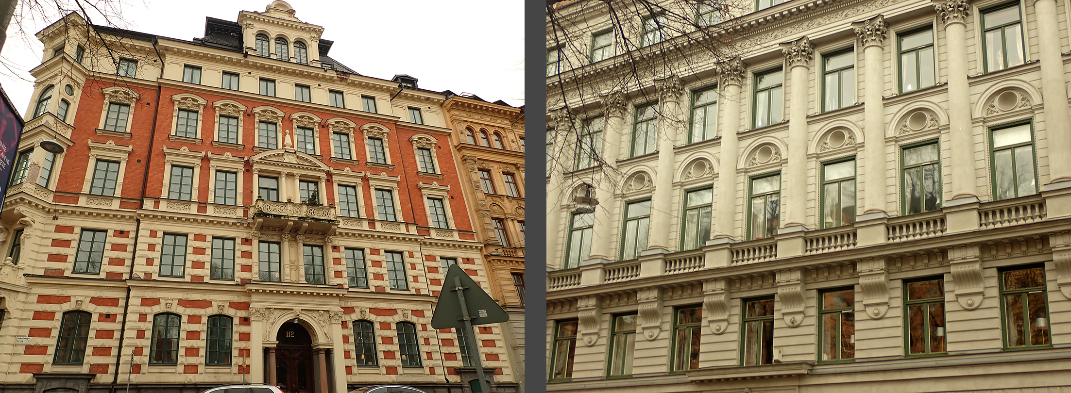 |
| facades on Valhallavägen and Karlavägen |
while the plainer facades are to be found on the narrower cross-streets.


One of the most important aspects of Lindhagen’s plan that is also reflected in Östermalm is the hierarchy of streets. While the majority of streets are relatively narrow with everyday city blocks, the boulevards provide a much needed contrast with their greenery, their openness, and their more elevated civic nature.

One thing that I noticed during my wandering up and down Östermalm’s streets is that the north-south streets are predominantly (but not entirely) residential on the ground floor
 |
| residential ground floors on Jungfrugatan and ? |
 |
| Both east-west streets Karlavägen and Storgatan are lined with commercial activity on the ground floors. |
I mentioned above that Birger Jarlsgatan on the edge of Östermalm is a hotbed of activity, but I also noticed that the blocks just to the east of Humlegården Park, close to the street Sturegatan, have a concentration of modern office buildings. It makes sense that these would be concentrated more toward the city center than on the distant edge of the neighborhood, but I’m not sure why they are concentrated by the park. It's ironic because the park is one of the city's most desirable addresses, but the nearby blocks of office buildings are the area's ugliest due to their awkward proportions and lack of detailing.


Many of Östermalm’s streets are blocked off to thru-traffic. For example, many streets have a small pocket park at their edge at Valhallavägen instead of having a direct connection with the boulevard. This certainly reduces car traffic in the neighborhood while still allowing pedestrian access, but it does contribute to the neighborhood feeling disconnected from the rest of the city.
 |
| This little pocket park is a lot less dismal-looking in the summer when it is green! |
This area of town was traditionally and even administratively known as Ladugårdslandet, or “Barn Land.” The name originally referred to the fact that the Crown’s stables and livestock barns were in the area—other clues to the area’s use for providing food for the royal table are Kungsträdgården, or the “King’s garden,” which was originally the palace’s kitchen garden as well as Humlegården, or “Hops Garden,” which was originally the hops-growing garden which provided for the palace’s beer supply. Both are now large, leafy city parks. The Crown’s livestock barns were eventually moved farther out of town, but the name stuck and came to denote the area’s rural character with its many small-scale farms, barns, cottages, and kitchen gardens. Even when the area began to be developed with fancy, expensive apartment buildings, frequent pockets of this smaller scaled and more rural settlement pattern remained, side-by-side with the large apartment buildings.
 |
| **This farmhouse wasn't demolished until 1907 |
In 1885, a private citizen petitioned the city council to change the area’s name to Östermalm, or “Eastern area.” Norrmalm, or “Northern area,” was already an established name so Östermalm wasn’t an unreasonable proposal. This new name was much more neutral and didn’t have the negative connotations that “Barn Land” had had, and it was more in keeping with the area’s current desirable status. The proposal was accepted by the city council and the area’s name was officially changed.
Conclusion
The plan for Östermalm is yet another example of how planning in Stockholm in the 1800’s was an incredibly sluggish process. Ceaseless rounds of proposals and counter-proposals, debates and votes and re-votes, disagreements between designers, the city, and the Crown, and general hemming and hawing, all during the city’s worst housing crisis and biggest growth spurt ever point to the fact that neither the city’s administrative organization or the city’s planning organ were the least bit efficient or effective. Yes, a plan was finally agreed upon, but the process took eighteen years despite the desperate need for land to develop into housing.
In the end, the plan was nearly identical to Lindhagen’s original proposal. The left-out diagonal boulevard was an unfortunate, short-sighted decision that continues to have a negative impact on the neighborhood as it is quite cut-off from the rest of the city, but in the end, despite so many rounds of proposals and counterproposals and resistance to the grandiosity of Lindhagen’s ideas, the plan ended up being much like Lindhagen’s original plan. The process of planning Östermalm shows how revolutionary, forward thinking ideas sometimes need to be given time before the rest of the community has matured enough to understands the idea’s finer points. How much more efficient it would have been if the city had been able to trust Lindhagen’s ideas from the beginning!


Sources
Gösta Selling, Esplanadsystemet och Albert Lindhagen: Stadsplanering i Stockholm åren 1857-1887 (1970)
Thomas Hall, Huvudstad i Omvandling (2002)
Raoul F. Boström, Ladugårdslandet med Tyskbagarbergen blir Östermalm (2008)
Images
All images are my own except
* Gösta Selling, Esplanadsystemet och Albert Lindhagen: Stadsplanering i Stockholm åren 1857-1887
(1970)
** Raoul F. Boström, Ladugårdslandet med Tyskbagarbergen blir Östermalm (2008)