I have a particular interest in this plan because I live on the island of Kungsholmen. I love the Kungsholmen life! There’s so much that is great about the island—all of the waterside promenades, the abundance of green space, the proximity to downtown, the hub of public transportation, the profusion of restaurants, the strollability, the waterside cafés and bars and gelato stands, the presence of a neighborhood bookstore and a library, the sense of living in a defined neighborhood but within a large city... I really could go on and on. Kungsholmen does have its fair share of planning mishaps (read below about the highways Essingeleden and Drottningholmsvägen), but its charms manage to far outweigh these barriers.

Even though I run and walk parts of Kungsholmen every day and know parts of the island inside and out, I had never systematically strolled every street of the island and had never studied the planning history of the island. I’ve seen and learned so much, and it has been tremendous fun to become even better acquainted with my island.
Proposals and Counter Proposals
1) Lindhagen’s original 1866 plan for Kungsholmen featured a somewhat regularly gridded area to the east and gigantic swaths of greenspace to the west. The orientation of the eastern grid is original from the 1600’s and points to the Royal Palace on Gamla Stan but the one strip of development to the west has an entirely different orientation, this time connecting from quay to quay—one of Lindhagen’s signature planning devices was to orient axes either toward the water or to parks, making park and water views a prominent and recurring theme for the city. These grids are cut with diagonal boulevards connecting the mainland and the suburb of Bromma (red), through a Baroque-inspired planted traffic circle (brown), to a new bridge and to downtown and the central train station. Several other boulevards would shoot off the same Baroque traffic circle including today’s Hantverkargatan (yellow) leading to another bridge toward downtown, today’s St. Eriksgatan (orange) leading to a bridge toward Vasastan, and another random diagonal shooting off into the parkland of western Kungsholmen on axis with Karlberg Palace (unlike most European cities, it is unusual that Stockholm’s axes lead to a manmade monument). Lindhagen’s rond-point was tangential to Kronoberg, a big bulb of granite that he set aside as a park (medium green).
 |
Lindhagen’s original 1866 plan for Kungsholmen (*)
|
While the eastern half of the island was to be more densely developed than the western half, there were still to be a large number of green spaces to the east. Two were existing green spaces around an existing church and military hospital while two others were located where the terrain was trickily steep. The boulevard from Bromma (today’s Drottningholmsvägen, red) was to be tree-planted, as was the proposed waterside boulevard (today’s Norr Mälarstrand, purple). Development on the western half of the island was to be set back from the streets with green gardens. The existing tree-planted extra-wide street at Kungsholmstorg (turquoise) was to be extended across the island and terminate at a park.
One of the main critiques of the Lindhagen Plan was that he willfully ignored topographical reality when it suited the plan. The plan for Kungsholmen illustrates this where north-south streets crossing the island somehow mysteriously navigate the several-story height difference between the body of the island and the water along the north shore.
In this plan, Lindhagen has evened out the shoreline creating smooth swoops of quayside. Only the southwest area of the island is left with its natural shoreline.
2) After the Lindhagen Committee presented their plans for Stockholm, the city did nothing for a decade. But by 1876, the conversation turned back to the need for a comprehensive city plan, and Lindhagen dusted off and revised his plan for Kungsholmen. Because of strong critique against the original plan where large areas of already developed land would have be razed in order to realize the plan, Lindhagen’s revised plan left the already developed eastern tip of the island intact. These existing streets informed the new grid that marched across the island.
 |
Lindhagen's revised plan for Kungsholmen from 1876 (*)
|
This revised plan still has extremely large areas of open green space (light green), especially where the topography is steep and hard to build upon, but this revised plan called for more development on the western half of the island. Again, the grid on the western half of the island is shifted so that both ends of the axis point to water.
In this plan, the boulevard leading from suburban Bromma to downtown (red) is arrow straight and meets another diagonal boulevard at a giant traffic circle (brown) that completely erases the high, steep terrain at Kronoberg (translates to “Crown Mountain”). Another boulevard leading to a bridge to Vasastan tangentially meets the traffic circle (orange). Strangely, a double-wide, crooked boulevard runs from one side of the island to the other, but it doesn’t connect any nodes and doesn’t seem to have much of a purpose. Hantverkargatan (yellow) does not connect to the traffic circle in this proposal. Except for the double-wide boulevard to nowhere, Lindhagen has given up his earlier ideas for tree-lined avenues and set backs creating gardens along the streets in the western part of the island.
Lindhagen’s earlier vision of an evened-out shoreline of built-up quaysides except for the southwest part of the island remains intact in this plan.
3) In 1877, the city council drew up a counter-proposal where more of the island would be developed into city blocks, though there was still a lot of undeveloped land left over. However, large parts of the western part of the island are not designated as parks in this plan. I am not certain if they were too “wild” to need a “park” designation, or if the city was reserving these areas for possible future development.
 |
The city council's counter-proposal from 1877 (*)
|
In this plan, the direct route from Bromma, across the island, and then to downtown is gone; instead, the crooked route from Bromma (red) follows its existing path and leads to a traffic circle (brown) and then turns almost 90 degrees onto another boulevard. Strangely, this boulevard doesn’t match up with a bridge to the mainland and Vasastan; instead, the bridge is two blocks over (orange). This plan introduces another wide street, today’s Fleminggatan, but this street doesn’t match cleanly up to a bridge to the mainland, either. Only Hantverkargatan, a relatively small street, continues directly on a bridge to downtown (yellow).
In this plan, the traffic circle (brown) does not coincide with the island’s steep high point at Kronoberg (dark green) but instead coincides with today’s Fridhemsplan where the tollbooth had always stood. Kronoberg becomes a park but is buried within the grid structure; it does not provide an axis for the Drottningholmsvägen thoroughfare coming from Bromma.
Like Lindhagen’s plan, this plan leaves the existing development in the eastern part of the island more or less intact. It also adopts Lindhagen’s deviant grid on the western part of the island, but there is now a large square where the axis meets the water at Rålamshov. Additionally, this proposal calls for a widened square at Kungsholmstorg which was to become a food market (turquoise). Most of the streets are treeless, but there are two seemingly random tree-lined streets at the edges of the development on the western part of the island. Like Lindhagen, this plan provides for a very wide street along the southern shore (today’s Norr Mälarstrand, purple). However, Lindhagen’s trees are gone and the city had plans to use the quay as a harbor.
Interestingly, the city council adopted Lindhagen’s idea to smooth out the shoreline and to create built-up quays. While this would make the waterfront accessible to the public, it would be a hinder to the island’s industries which relied on the water’s proximity, it would require the expropriation of a great deal of land, and these quays were expensive to build. Given the council’s inclination to do as little as cheaply as possible, I am surprised but glad that Lindhagen’s quays survived the council’s “value-engineering” hatchet.
4) Plans 2 and 3 went up for a vote in 1877 and Lindhagen’s plan won but with a couple of adjustments. First, Drottningholmsvägen from Bromma was to be less extravagantly wide and it would stop at the park at Kronoberg; there would be no thoroughfare cutting across the island directly to downtown. The city council thought that it was especially important to keep the western part of the island green as in Lindhagen’s plan, and that the greenspace should be connected across the island.
5) In 1878, Lindhagen adjusted his plan from 1876 so that Drottningholmsvägen (red) doesn’t continue through the eastern part of the island but just randomly peters out. Instead, the giant two streets (orange) leading off the giant traffic circle (brown) around the Kronoberg bulb (dark green) would connect with bridges to Vasastan.
 |
| Lindhagen's adjusted plan from 1878 (*) |
6) In 1879, a city committee member who had just moved to Kungsholmen drew up his own plan. Poignant’s plan was similar to the city’s plan in that he thought that Drottningholmsvägen should terminate at Fridhemsplan (brown) a couple of blocks before the park at Kronoberg (dark green). From the traffic circle, the main boulevard should turn north, only to turn east again onto a widened Fleminggatan, which would widen again at the eastern tip of the island in order to connect to a bridge into downtown. He also thought that setbacks were appropriate west of Fridhemsplan. And to add a little flair to the plan, he drew in a rond-point at the bend in Drottningholmsvägen. Poignant didn’t seem to be very concerned with a direct connection norward to Vasastan.
 |
Poignant’s 1879 plan for Kungsholmen (*)
|
Importantly, this is the first plan in Stockholm’s history that I am aware of that has contour lines overlaid on the street grid. The first early planners were aware of topography but didn’t seem to know how to handle it. Lindhagen, for example, shaded cliff faces on his plans and he designated many steep and bulby parts of Stockholm as parks because he knew that these areas would be hard to build upon. However, he also drew streets that crashed over the sides of cliffs. Poignant’s plan didn’t do any better with the unrealistic street grades toppling over cliff faces, but his awareness and inclusiveness of contour lines on his plan was an important step. It’s not clear that later planners gleaned the importance of topography and contour lines from Poignant, but he seems to be the first to scientifically show topography on his plan rather than shading in an approximation.
7) Now it was time for the city to draw up a plan ostensibly based on the vote in 1877. However, this new plan from 1879 looks a lot like a formal version of committee member Poignant’s plan. The only difference is that the western traffic circle disappeared.
 |
The city's 1879 plan for Kungsholmen (*)
|
8) Of course Lindhagen had to come with a counter-proposal later in 1879. This time, Lindhagen wasn’t content to go back to his plan that had won, with some adjustments, 1877’s vote. No, this time, Lindhagen more or less re-drew his original proposal from 1876 where Drottningsholmvägen (red) shoots straight across the island from the bridge to Bromma to the bridge to downtown. Lindhagen argued that diagonal streets are better for traffic flow than the many turns in Poignant’s plan, that everyone else in Europe was creating diagonal streets (i.e. Paris and Berlin), that they create variation and a more interesting cityscape, that they do not cost more, and that they create opportunities for striking architecture (like
Birger Jarlsgatan). (Interestingly, these arguments are well-supported in a recent study of Haussmann’s Paris,
Koden för en bra stad.)
 |
Lindhagen's counter-proposal from 1879 (*)
|
Furthermore, Lindhagen argued that a monument atop Kronoberg (dark green), in the middle of his giant traffic circle (brown), would be visible from downtown and from the water of Riddarfjärden and simply must be built. A bit ironically, considering his grandiose monument, Lindhagen then goes on to explain that Kungsholmen would be home to dirty industries and to industrial workers. Therefore, setbacks and gardens along the streets are not appropriate for western Kungsholmen—setbacks and gardens along the streets are appropriate for neighborhoods of single-family houses, not for worker’s housing.
Although Lindhagen was generally very assertive that Kungsholmen should have a straightforward and direct connection to Vasastan, he did not show this connection in this plan.
9) In 1879, the city council voted again. There was a lot of opposition to the public street and quay at Norr Mälarstrand because the water needed to be accessible for industrial use, but these voices eventually lost. The council voted for proposal #7, but of course with some reservations. In a nod to the opposition, both Norr Mälarstrand and Fleminggatan would be reduced in width to provide more area for industries. Drottningholmsvägen would be according to Lindhagen’s proposal #5—straight from Bromma to Kronoberg, but it would not continue to downtown. However, this thoroughfare would end at Fridhemsplan, not the park at Kronoberg.
10) In 1880, the city drew up a new plan to reflect the 1879 vote. Here, the traffic circle at Fridhemsplan becomes merely a widened triangular intersection (brown). There’s a little extra flair where the Boulevard from Bromma (red) lands on Kungsholmen—the boulevard splits around an oval park.
 |
The city's plan for Kungshomen from 1880 (*)
|
11) Again, Lindhagen was tireless in trying to push his ideas through and he came with another counter-proposal in 1880. This time he had given up just about all of his ideas except for the idea that the thoroughfare Drottningholmsvägen (red) should continue all the way to the park at Kronoberg (dark green), providing a green end to this important axis. Lindhagen’s straighforward connection north to Vasastan (orange) reappears in this plan.
 |
| Lindhagen's counter-proposal from 1880(*) |
12) It’s hard to know if the city council finally understood the genius and importance of Lindhagen’s green axes or if they were just tired of fighting with Lindhagen, but in 1880 the city council adjusted its plan and accepted Lindhagen’s idea that Drottningsholmsvägen (red) should end at the park at Kronoberg (dark green). Also, they finally grasped that if the “thoroughfare” was going to be turning 90 degrees, it at least had to directly connect to a bridge to Vasastan (orange).
 |
The city's 1880 adjustment to its plan for Kungsholmen
|
13) In a final vote in 1880, the city council approved this adjusted plan (#12).
14) The King then approved the plan later in 1880, with the reservation that land owned by the Crown would not be officially included in the plan. Because of the army hospital and a number of army barracks along the southern shore of the island, Norr Mälarstrand (purple) and the neighborhood immediately to the north of this waterside boulevard wouldn’t be built until the 1920’s. While this plan has a lot of undeveloped land to the west, it is unclear on this black and white copy how much of this open space was officially designated as parks. I assume that the official parkland corresponds to map 10 above.
 |
The final, approved plan for Kungsholmen (*)
|
Post-Plan Development
 |
Kungsholmen today with the same color code as above
|
Stockholm was suffering from a housing crisis, so eastern Kungsholmen was intensely developed in the decades after the plan was ratified. There are a few smaller-scale buildings from before the plan ratification, but the majority of the original, older buildings were demolished to make way for larger apartment buildings.
There was another intense spurt of development in the 1920’s and 30’s as industries began to move out of town and as the Crown’s land was turned over to the city. This era of development is represented by a large number of infill projects as well as the entire Norr Mälarstrand area.
Large blocks of the eastern half of the island were redeveloped in the 1950’s and 60’s after another wave of industry closings.
The western half of Kungsholmen was developed in different spurts including the 1930’s, the 50’s, and the 60’s--more on these areas below. The next large development was the St. Erik’s area in the 1990’s.
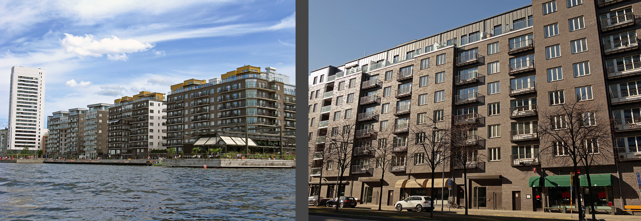
And now in the 2010’s and 20’s, the Hornsberg area is under redevelopment from an industrial area to housing and offices.
There are still traces of the island’s industrial past, but there are no comprehensive industrial areas remaining on Kungsholmen. There is very little visible evidence that the island was once almost exclusively inhabited by the working class who worked in the bygone factories. Real estate prices certainly do not reflect a “working class” spirit!
Grids and StreetsThe eastern half of the island (yellow) has a fairly consistent street grid, but the western half is broken up into several different grids. The streets in the Thorildsplan area from the 1920’s have Lindhagen’s original divergent street orientation that was meant to span the island from waterfront to waterfront (orange). The recent development in Hornsberg (brown) continues the Lindhagen/Thorildsplan orientation to the water’s edge to the north, but the street grid never did reach the water on the southern side of Lindhagen’s axis. Large parts of the more suburban areas have less of a “grid” and more of a street “network” (red) Each epoch of development in the western part of the island has its own type of street network according to the vogue of each era.

Most streets on Kungsholmen are only a block or two long, even in the gridded and more consistent eastern half of the island. This is an unusual phenomenon for Stockholm and seems to be due to the island’s abrupt geology. With the abundance of steep cliffs, it is simply not possible for a street to continue in the same direction for very long. Only two streets manage to overcome the topography to bisect the island in the north-south direction. Even Kungsholmen’s main thoroughfares only continue across half the island in the east-west direction. This was a conscious decision on the city’s part in order to reduce disruption in the already built-out areas of the island.
All of the plans from the 1800’s show streets stretching from the middle of the island all the way to the water’s edge. Much of the island’s shoreline consists of granite cliffs, so these plans were never very realistic. Today, several streets dead end atop the cliff and only a pedestrian stairway navigates the elevation difference.
The streets that do navigate these dramatic elevation changes cut diagonally through the cliff side and are dynamited into the bedrock.
Some streets that navigate somewhat less elevation change do plunge right down; these streets are far steeper than anything we’d build today.
From Bromma into town
Despite repeated efforts, Lindhagen never did get his arrow-straight boulevard from Bromma to downtown (red). Instead, the city council’s proposal won out, and the thoroughfare from Bromma is neither a straight shot across the island nor does it connect directly to downtown. Once it gets to Fridhemsplan (brown), the “thoroughfare” takes a 90 degree turn north. Continuing north, there’s a direct connection to Vasastan (orange), or after another 90 degree turn, there’s a connection to downtown near the central train station. More on this thoroughfare below.
FridhemsplanFridhemsplan, or “Peaceful Home Square,” was the location of the old toll booth from when Stockholm was surrounded by a toll fence and it marks the seam between “city” and “suburbia” on Kungsholmen. It was here that the thoroughfare from Bromma, Drottningholmsvägen, was to turn northward and head over a bridge to the mainland. This street junction was eventually moved one block eastward to St. Eriksgatan, making Fridhemsplan itself a leftover triangular space where the street grids shift slightly. This little green space is used for a fruit stand in the summer and a Christmas tree stand in December, but it is otherwise an unwelcoming and underused space—there aren’t even any benches.
Additionally, Drottningholmsvägen’s axis toward Kronoberg Park that Lindhagen fought so hard for is a bit of an anticlimax today because the view into the greenspace is partially blocked by the ugly entrance to a parking garage blasted into the granite under the park.

Like Karlaplan in Östermalm, Fridhemsplan could have been a beautiful oasis in addition to being an important traffic junction, but Lindhagen’s monumental traffic circle was “value engineered” away. Today, Fridhemsplan is just a junction of two major thoroughfares, not a “place” or “square” as the name would suggest.
Parks, Greenspace, and “Unplanned” Development
The final plan for Kungsholmen did not call for a lot of greenspace on the eastern half of the island apart from the park on the island’s highest point at Kronoberg. However, small parks are sprinkled throughout these neighborhoods today. The 1880 plan never did account for Kungsholmen’s sharp topography, and many of today’s greenspaces are “left over” areas that were difficult to build on. Also, eastern Kungsholmen is home to a number of large city institutions as well as a historic church, and each of these sits in its own green space.

Additionally, two large areas of eastern Kungsholmen, Norr Mälarstrand and Gubbensringen, were not developed until much later (1920’s and 1990’s respectively) and by that time parks were considered an obligatory necessity.
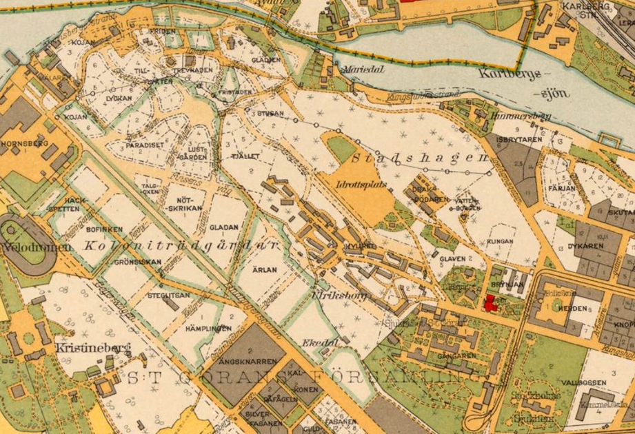
Ironically, while the eastern part of the island is greener than planned, the western half of the island is much more developed than originally planned. Fredhäll, Kristineberg, Stadshagen, Marieberg, and Hornsberg were all supposed to remain undeveloped parkland. However, from the 1930’s through today, these areas have been developed and each development reflects its epoch.
A small area of Fredhäll was to be built as traditional city blocks according to the 1880 plan, but in the early 1930’s, the entirety of Fredhäll was developed in a more suburban pattern with free-standing buildings set apart from the street and from each other. Parts of the development were long, low-rise buildings set back from the street while other parts consisted of higher apartment towers. Fredhäll is a very verdant neighborhood, the streets are still relatively small-scale and very walkable, and many of the buildings, while restrained, have just enough detailing to make them interesting. Fredhäll manages to still feel like it’s a part of the city despite its suburban character.


Kristineberg was also developed in the 1930’s, but being built in a pure, modernist spirit, this neighborhood has a much more severe atmosphere than Fredhäll. Here, freestanding buildings are set amidst green lawns without many trees. Because the buildings are quite austere and there is a total lack of cafés and restaurants, Kristineberg does not feel very urban despite its relatively high density.


Both Stadshagen and Hornsberg were developed into a dense industrial areas starting in the 1930’s (more on Hornsberg’s fate in my next post). Much of Stadshagen was redeveloped into housing in the 1950’s and then additional large areas were redeveloped into apartments and offices in the early 2000’s, but both areas’s redevelopment into dense blocks of offices and apartment buildings is still ongoing. Stadshagen’s 1930’s-60’s apartments are freestanding “buildings in the park” a la Le Corbusier, but the overall impression is that the green areas are more leftovers than planned parks. Stadshagen’s buildings are much more cut-off from the street than in Fredhäll and Kristineberg, creating large vacuums of space around the streets. The area doesn’t feel very urban or walkable.


Marieberg was developed in the 1960’s 1980’s and and here the car has taken over with wide streets and large surface parking lots. Marieberg is both a industrial/commercial area as the newspapers built giant towers here while the rest of the area was developed into housing with stand-alone apartment buildings surrounded by greenspace. Marieberg feels like less of a neighborhood than nearby Fredhäll because of the higher scale of the buildings, the less cohesive street fabric, and the large, segregated commercial district.
Despite the development of Fredhäll, Kristineberg, Stadshagen, Marieberg, and Hornsberg, there is still a concentration of greenspace on the western half of Kungsholmen with its interconnecting parks, especially along Drottningholmsvägen’s southern side.
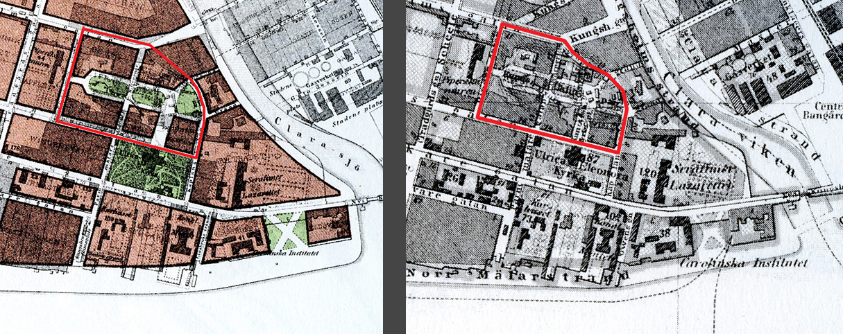
One terminus of this interconnected park system, Rålambshov Park, nicknamed Rålis, was not planned to be a greenspace from the beginning. It is a full-fledged city block in Lindhagen’s earliest plans (left below) and became a large, open square in the city’s proposal from 1877 (right below). This large square was included in all subsequent plans, but the square was never built, probably because the land belonged to the Rålambshov malmgård (suburban farm) (see #27 here). The area was instead developed into a park in the 1930’s, connecting with the linear park through Fredhäll. Today, Rålambshov is one of Stockholm’s most popular and heavily used parks.
 |
(*) (*)
|
Street Trees, Setbacks, and SquaresIn the 1880 plan, several of Kungsholmen’s main thoroughfares were to be tree-lined. A couple of these streets (Lindhagensgatan and parts of Drottningholmsvägen and Fleminggatan) have only recently received their trees while the other streets remain treeless.

There was a good bit of back-and-forth as to whether the streets on the western half of the island should have setbacks with strips of greenery between street and building. The ratified plan for Kungsholmen did call for setbacks in the west, and Thorildsplan was built with green setbacks along one side of the street. There are setbacks in Kristineberg and Fredhäll, but these areas were not really included in the ratified plan and these setbacks are a result of the 1930’s era of planning. The only area on the eastern half of the island with setbacks is Norr Mälarstrand which was built at approximately the same time as Thorildsplan. Here there are setbacks along both sides of the street. Norr Mälarstrand was drawn as “regular” city blocks in the ratified plan but was eventually built according to an entirely new plan.

Aside from Fridhemsplan described above, the island’s only other “square” is Kungsholmstorg. This square was originally the island’s main food market. Lindhagen planned for a widened street which would continue across the island. In the ratified plan, the square was to be widened, and this is what was eventually built. I am unsure if the square was meant to continue as a food market (probably). There’s a small fruit and vegetable stand here today, but the rest of the square is a much-needed green space in the middle of a very dense area.
Kungsklippan (“King’s Cliff”) In Lindhagen’s original plan (left below), the high and steep Kungsklippan or “King’s Cliff” above the Kungsholm’s Church was to become a park, but in his revised plan from 1876 where the existing buildings on the eastern part of the island were to remain intact, Kungsklippan was left unplanned. I am intrigued that this cliff was so formally planned in the city’s proposal from 1877 (right below). A narrow, oblong park was to be ringed by streets and blocks of apartments. This was an unusually finely-tuned and small-scale planning move in this era of sweeping, generalized city plans, and I am guessing that one of the city-council members (a large portion of the city council seats were occupied by real-estate developers) had bought the land and wanted his proposed development included in the plan; I’ll research this more at a later time.
 |
| (*) (*) |
This design for Kungsklippan was included in all subsequent proposals (left below) and was part of the final, ratified plan (right below).
 |
| (*) (*) |
Interestingly, most of Kungsklippan wouldn’t be developed until the 1930’s and while the separated apartment buildings which are classic examples of modernist planning and architecture and were definitely not what the planners of the 1870’s had in mind, the central oblong park ringed with streets was executed as originally planned. Kungsklippan is an interesting example where different planning eras collide, producing a richer environment than either era would have achieved on its own.
Quays and ShorelineI wrote above that Lindhagen’s original plan called for an evened-out shoreline and built-up quaysides along much of the island’s waterfront. Only the southwest area of the island was to be left with its natural shoreline. This was appropriate since the southwest area of the island was to be undeveloped parkland. I also wrote above that I am surprised that the city council adopted Lindhagen’s idea to smooth out the shoreline and to create built-up quays because it was an expensive and somewhat unpopular idea.
Today, Kungsholmen’s shoreline is much as Lindhagen and the city council planned, even if there aren’t many stretches of built-up quaysides. First of all, much of the shoreline was smoothed out into swooping arcs by filling in the water to create new dry land just as Lindhagen proposed, but the southwest side of the island retains its natural shoreline. There are two long stretches of built-up quaysides on the island, one in
the southeast along Norr Mälarstrand and another on the northwest at
Hornsberg Strand. The quay along Norr Mälarstrand was meant for
strolling while the quay at Hornsberg was originally for industrial
purposes.
The rest of the smoothed-out shoreline looks more natural
even if it is not actually a natural shoreline. These shorelines are
lined with rocks, bushes, reeds, trees, and patches of grass as well as
walking paths.
The only part of Kungsholmen’s shore that does not have a
man-made quay or walking path is the southwest area where the natural,
steep shoreline cliffs were left intact.
Bifurcation
Kungsholmen’s planning history was a long, tortuous process just as it was for Östermalm and for Norrmalm. But one thing that really stands out for me when comparing Kungsholmen’s plan to those for Östermalm and Norrmalm is that the plan for Kungsholmen includes a large area outside of the city’s traditional toll-fence boundary.

Even though tolls into the city stopped being charged a couple of years before the plans were first sketched, the plans for Östermalm and Norrmalm stop at exactly the same boundary where the city had always abruptly stopped—at the toll fence—because the land outside of the toll belonged to the Crown, not to the city. Wallström and Rudberg’s first early plan for Kungsholmen stopped at the toll fence, but later plans, including the officially approved plan for Kungsholmen, all include the entire island and not just the eastern half that had been inside the toll fence. The reason for this is that the city of Stockholm has owned the entire island since the King donated it in the 1600’s. Expansion into the western half of the island had never been necessary, but now the city’s population was booming and it would have been short-sighted not to include as much surface area as possible in the plan. The plan, after all, was meant to encompass all of Stockholm.
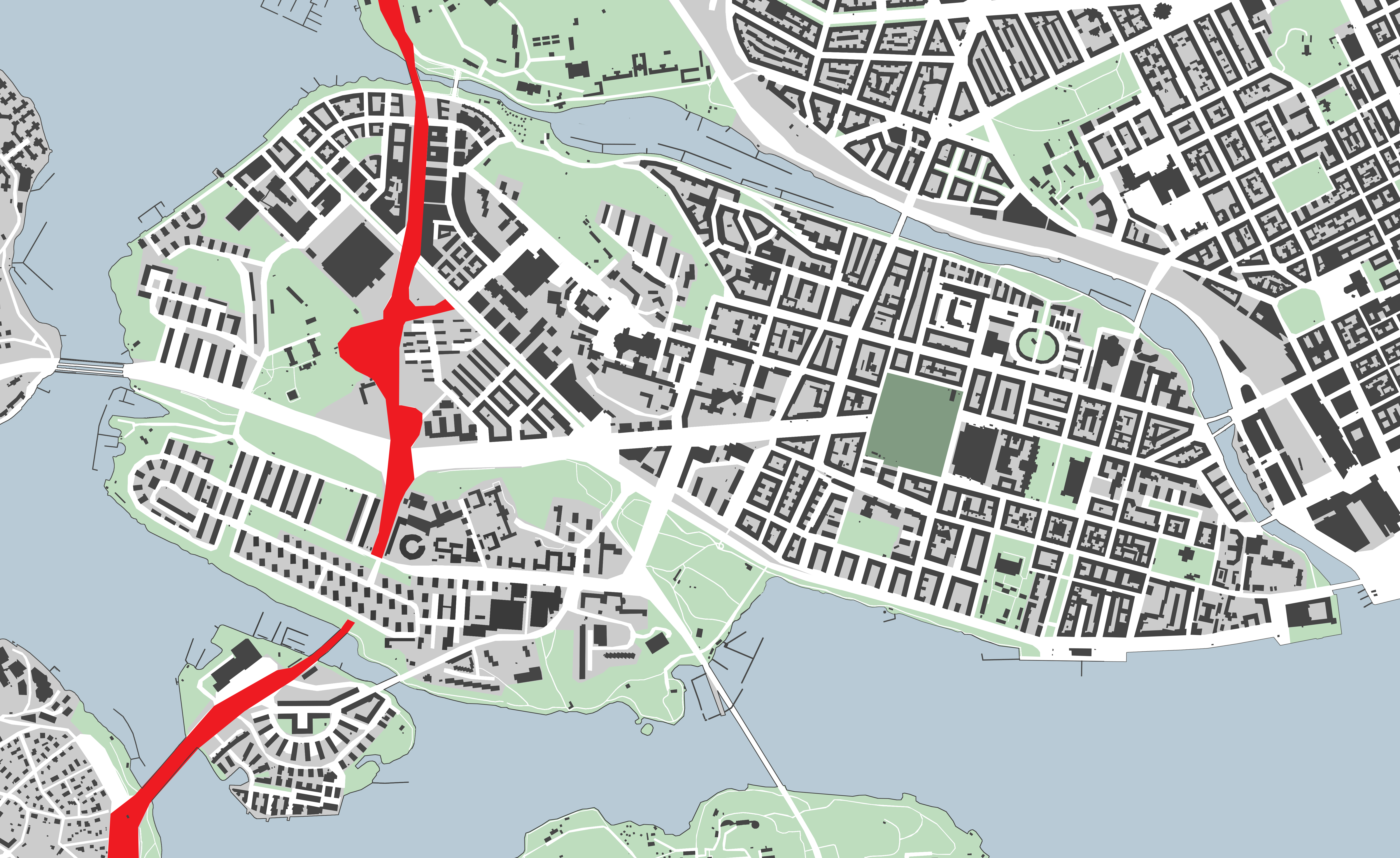
With that in mind, however, the plan for the western half of the island has a completely different character than the plan for the eastern, inside-the-toll-fence half. The eastern half was planned as a traditional and rather dense city grid, but the western half is almost completely dedicated park space with one strip of dense city bisecting the green areas. It was as if the planners still couldn’t conceive of Stockholm ever growing that much.
 |
The east and west sides of the street Fridhemsgatan. Left: traditional city blocks inside the toll boundary. Right: towers in a park outside of the toll boundary.
|
This bifurcation of Kungsholmen is still easily visible in the city fabric today. The eastern, “urban” part of the island has a traditional grid structure with closed city blocks (yellow), but the development of the western part of the island has a very “suburban” character where most of the buildings are set far apart from each other with a lot of greenspace in between (red). This bifurcation has only very recently been made somewhat less clear with the development of Hornsberg Strand into traditional blocks on a grid—this area has been mostly built in the 2010’s and is still being built out today (brown). Interestingly, this newly gridded area follows Lindhagen’s shifted axis even though this axis doesn’t relate to anything else in the city except for the nearby Thorildsplan area (orange). The main axial street is even named after Lindhagen; modern planers clearly aimed to realize this "forgotten"part of the Lindhagen Plan.

In more modern times, the original east-west bifurcation became even more pronounced when a highway (Essingeleden) was built across the island starting in 1960. In order to largely spare the already developed and very popular residential area of Fredhäll, the highway was dug into a tunnel through the south side of the island. But where the island was less developed and more industrial than residential, the highway was built high up on a series of bridges, creating a noisy, shadowy and unpleasant corridor cutting across the island. Unfortunately, the highway was allowed to remain a brutal barrier when the Stadshagen och Hornsberg Strand areas was planned and developed; this gaping wound through Kungsholmen’s fabric may never be healed.


Kungsholmen is most obviously bifurcated on the north-south axis due to the toll-boundary described above, but the western half of the island is additionally bifurcated on the east-west axis by Drottningholmsvägen. This road is not quite a highway, but it is a higher-speed artery connecting from Kungsholmen to the mainland and the suburb of Bromma and beyond.
The original bridges between Bromma and Kungsholmen were floating bridges, but these had to be removed during the winter. Bromma was disconnected from town during the in-between seasons when the ice was too thin to cross. A very high, permanent bridge was built in the 1930’s and this bridge lands on the island well above the natural grade. It takes a while for the thoroughfare to descend all the way to the ground, creating a very solid and long barrier between Fredhäll and Kristineberg. Furthermore, the subway pops out of its tunnels here, too, making more of a barrier even when the thoroughfare is at grade.
The Thorildsplan development from the 1920’s fronts Drottningholmsvägen as if it were a regular city street and not an almost-highway plus the additional noisy barrier of the subway. Clearly this thoroughfare had an entirely different scale and feel until at least the 1930’s.
Strangely, new development from the early 21st century “continues” Thorildplans development along Drottningholmsvägen as if it were a regular city street, and this meeting of residential city and highway feels misplaced and misguided today. Maybe the planners had a very long-term vision of redeveloping Drottningholmsvägen into an urban street despite the lack of any concrete plans to do so...?


Another highway-esqe barrier is the bridge Västerbron (“The Western Bridge”) and its continuation Lilla Västerbron (“Small Western Bridge”). Västerbron was finished in 1935 and connects Kungsholmen to the islands of Långholmen and Södermalm and beyond to the southern suburbs. This elevated almost-highway continues through the non-place of Västerbroplan (“Western Bridge Square”) over a low area and connects up to Drottningholmsvägen, the thoroughfare from Bromma into the city. These bridges create such a major barrier that no streets cross from one side to the other. However, the greenspaces do continue under the bridges. The greenspaces change character from one side of the bridge to the other, but it is a fairly seamless experience to walk or bike from one greenspace to the next.


Due to Essingeleden, Drottningholmsvägen, and Västerbron, the barrier-baggage of the car-dominated planning era of the 1950’s-1970’s is more visible and more felt on Kungsholmen than in most of the rest of central Stockholm. These barriers are easy to ignore and forget on the eastern, urban half of the island, but they only reinforce the suburban character of the western half of the island.
Conclusion
In retrospect, especially considering how dreadful Drottningholmsvägen turned out, it is a win for Kungsholmen that Lindhagen never got his way with the thoroughfare shooting directly from Bromma to downtown. Even if the thoroughfare had been treated more like Birger Jarlsgatan creating a rich canvas for architecture and street life, the thoroughfare would have completely changed Kungsholmen’s character from a relatively quiet but “happening” neighborhood to a more intense, connected cityscape.
And it is Kungsholmen’s apartness that is so appealing. It is so close to the center, but the waterways surrounding the island create just enough of a boundary to make Kungsholmen its own lovely world. Kungsholmen is well-connected to the rest of the city, and it truly feels like it is a part of central Stockholm, but it is its own entity with its own strong geographical and atmospheric identity.
Kungsholmen certainly has its weaknesses, especially the bifurcating almost-highways, but somehow, the positive aspects of Kungsholmen, especially its abundance of interconnected greenspaces and its constant contact with the water, manage to outweigh the negative aspects. While other areas of Stockholm also have an wealth of green areas, these green areas are often not as well connected to each other. Many of Kungsholmen’s green areas are linked together creating long bands of park weaving through the urban landscape. It is possible, for example, to completely circumnavigate the island on a 9 kilometer-long (5.5 miles) loop of parks in constant contact with the water and with only a single road crossing. Parts of this loop feel more urban while other parts feel more “wild,” creating a wide range of experiences. No other part of central Stockholm has so much contact with the water.

Quality of life on the island is extremely high. This high quality of life was partly shaped by some of the original planning strategies such as the abundance of short streets which help to reinforce Kungsholmen’s atmospheric identity of small-world neighborhoods. Other aspects were introduced later such as the two subway lines (starting in the 1950’s) that give the island an unusually dense network of efficient public transportation as well as the interconnected necklace of park paths from the 1930’s. The ratified plan from 1880 laid a good foundation for the area, but much of what gives Kungsholmen its appealing character came later.
SourcesGösta Selling,
Esplanadsystemet och Albert Lindhagen: Stadsplanering i Stockholm åren 1857-1887 (1970)
Sussie Bjuvstedt,
Essingeleden (1966)
ImagesAll images are my own except for
* Gösta Selling,
Esplanadsystemet och Albert Lindhagen: Stadsplanering i Stockholm åren 1857-1887 (1970)