 |
| Water reservoir at Vanadislunden and stone quay at Gamla Stan |
Sweden was one of Europe’s deadliest cities—the water sources were polluted and abundant swampy areas were breeding grounds for disease. Epidemics were common and more people died each year in Stockholm than were born. A third of all infants died in their first year. Extreme poverty and a series of country-wide crop failures and resulting rising food prices meant that dying of starvation was not an uncommon death in Stockholm. The only factor keeping Stockholm’s population somewhat stable was a constant stream of immigration from the countryside to the city.
Stockholm’s status as the country’s capitol and the seat of the monarchy had been favorable for the city during the 1600’s. At that time, the monarchy was wealthy and eager to develop the city into a capitol worthy of the expanding empire. The Crown both funded and controlled the city’s development. But when the Crown’s funds dried up at the beginning of the 18th century, the connection between the monarchy and Stockholm meant that the city had no funds of its own for continued maintenance and development. By the 19th century, the city was conscious of its deficiencies and had some (limited) desire to improve the infrastructure, but it had no power or money to take the necessary steps.
But in the middle of the 1800’s, everything changed. Sweden’s economy experienced the first real upswing for 150 years. Stockholm’s population began to grow, doubling between 1856 and 1884 from 100,000 to 200,000 people. To keep up with the population growth, the city began to build at record pace. Technology offered new solutions to old problems, and a general optimism and faith in technology’s ability to solve urban problems grew. It was felt that conditions in the city could hardly get worse; instead, life could only get better.
City Administration
The first ground-breaking change that laid the foundation for all other infrastructure improvements was that the city was finally granted the power to control its own fate in 1862. Stockholm was no longer directly under the control of the monarchy—both the administration of the city and the city’s tax base were turned over to a new, modernized city government complete with salaried, full-time employees. While the whims of the monarchy still played a defining role in the city’s development, the city now had the responsibility, the formal power, and some funding to act on its own.
With power and funding in hand, the city government got immediately to work improving the city’s infrastructure. These improvements fall loosely into three interwoven categories: improvements for the sake of trade and business (Streets and Sidewalks, Quays, Locks, Railroads, Horse-Drawn Trams); improvements for the sake of health and safety (Swamp Drainage, Street Lighting, Water, Sewage and Drainage); and improvements for the convenience and enjoyment of the city’s inhabitants (Elevators, Parks).
Streets and Sidewalks
 |
| Regeringsgatan |
Since the beginning of Stockholm’s history, streets were the responsibility of lot owners. As a lot owner, one was responsible for the street along one’s lot frontage, from the lot line to the middle of the street. Officially, lot owners were supposed to pave their streets with cobblestones, but this was in reality rarely done. Moreover, there was no coordination between one section of street and the next. Even if two adjacent lot owners dutifully paved their sections of street, there was no guarantee that the gradient of one street section would meet the cobblestones of the neighboring section. Steps and dips and potholes between one street section to the next were not uncommon. Needless to say, in this context, laying pipes for drainage, sewage, water, or gas was unthinkable.
In 1845, the city officially took over the paving and maintenance of streets. This was to be funded by a special new tax on property owners. In practice, there wasn’t much of an improvement until the 1860’s when the city administration was modernized and it finally had the staff to plan and carry out improvements.
 |
| Different types of street paving in 1871. Red=shaped stone. Green=field stone. Blue=macadam. Orange=gravel. (6) |
Once the city took over street paving and maintenance, a new innovation was introduced: sidewalks. There was an outcry of property owners against this “nonsense” because the curbstones made it more difficult for wagons to be driven onto the property. But the city won out, and Regeringsgatan in Norrmalm was the first street to be entirely lined by sidewalks. One block of the original sidewalk is still visible today; the rest of Regeringsgatan’s sidewalks have been repaved in the standard Stockholm concrete paving stone.
 |
| Regeringsgatan |
Quays
 |
| Stone quays built in the mid-1880's-ish |
In my post on “At the Junction of Geography, Geology and City Planning: Nybroviken, Raoul Wallenbergs torg, Berzelli Park, Nybroplan, and Norrmalmstorg,” I described how plans for the Nybroviken harbor languished for centuries. Despite active lobbying from the area’s residents and several iterations of plans drawn up by city architects, the city simply didn’t have the willpower or the funding to clean up the swampy, sewage-filled harbor or to build a quayside. It took a royal decree to spur action.
 |
| The stone quay at Nybroviken |
I think that Nybroviken’s story was fairly typical. Through the middle of the 1800’s, most of the city’s waterlines were muddy, polluted transitions from water to land. Boats tied up to trees and rocks or at best to rickety, wooden docks, not to an official, engineered quay of stone. Access to the water was often blocked by industries such as tanneries, which also spilled toxins into the water. Even Skeppsbron’s quay, built in the 1600’s to impress international visitors, was essentially a long, wooden dock.
 |
| Skeppsbron's stone quay |
The city awakened during the railroad debates of the 1850’s. Opponents to the “Wasp’s Waist,” the railroad connection on bridges from Södermalm to Norrmalm, narrowing the canal between Gamla Stan (Stadsholmen) and Riddarholmen, would rather have seen grand stone quays encircling the islands. They lost the railroad debate, but quays were built around Gamla Stan

and Riddarholmen

in the 1850’s and 60’s none-the-less. I believe that the quayside along Norrström was also built at this time.

Additionally, it was decided that future city development projects that happened to be at the water’s edge would include a stone quay. The first to be realized was Strandvägen; I will cover this project in much more detail in a future post.
Today, it's hard to imagine the city without these stone quays. In this day and age, the quays are not technologically impressive, and they seem like a natural, necessary part of the city. But only a century ago, these quays were expensive, difficult projects that replaced the age-old solution of rickety wooden docks and mud banks.
Locks
Locks
 |
| Slussen |
The very existence of Stockholm depends on its strategic location where the enormous Lake Mälaren empties into the Baltic Sea. It was here that the cargoes of seafaring ships had to be carried over the small rapid separating the bodies of water and reloaded into shallower lake-going boats. A riskier alternative was that seafaring ships could be reeled up over the rapid and into the lake by men pulling ropes. Either way, one of Stockholm’s most important sources of income was fees for the handling of goods or reeling of boats.
(Not only was Stockholm the crux of east-west water-borne transport, but the ridge extending from Södermalm, over to Gamla Stan, and up to Norrmalm was literally the only narrow crossing over Lake Mälaren for 100 kilometers. Naturally, the historical north-south road used this junction to cross the Lake.)
By the 1600’s, the continuing rising of the land combined with the growing size of merchant ships meant that neither the reloading of cargoes or the reeling of ships were viable alternatives any more. Luckily, the Dutch had developed the needed technology, and in 1637, Queen Kristina imported knowledgeable Dutch engineers who designed and built a wooden lock between Gamla Stan and Södermalm. The lock was opened in 1642, and the area around the lock became known as Slussen, which means “The Lock”.
 |
| Plan drawing of the Kristina Lock by Lorenzo Magalotti, drawn in the 1600's. (1) North seems to be down in this image. |
The lock was an immediate success. Stockholm’s income from lock fees immediately grew 600% larger than the previous cargo and reel fees. Sweden had always been an important exporter of iron, but the lock made export through Stockholm so convenient that iron export was suddenly concentrated to Stockholm; Stockholm’s harbor became the largest iron export harbor in all of Europe and fully 40% of all iron in Europe moved through the lock. The official city iron scale was moved to the now-dried up medieval moat just south of Slussen which became known as Järngraven or “Iron Moat,” and all export iron coming through the lock went through a weighing, quality control, stamping, and customs process housed on Södermalmstorg, the square adjacent to the lock. It wasn’t just iron that was suddenly concentrated to Stockholm; two-thirds of Sweden’s international trade was now transported through Slussen.
 |
| Kristina Lock shown on a 1650 copperplate by Wolfgang Hartmann (1) |
The lock was a commercial success, but it hadn’t done much to beautify or modernize Stockholm’s image. The lock was built in the shadow of Stockholm’s medieval wall and crumbling towers. Beside the lock, grinding mills still took advantage of the rapid which raged through Kvarnströmmen, or “Mill Stream.” Various boat sheds, fish cleaning sheds, and tanneries hung out over the water’s edge. In 1680, City Architect Jean de la Vallée drew up a plan to regularize, beautify, and modernize the Slussen area. In the proposal, a wide peninsula was to be built jutting out from Gamla Stan toward Södermalm. A double bridge would cross over Kvarnströmmen and a double drawbridge would cross the lock. The moat would be partially decked over and the area’s shoddy sheds would be replaced by large, well-built buildings according to a geometrical plan. The proposal was never built, but it did influence later development of the area.
 |
| Jean de la Vallée's proposal for cleaning up the area around the lock, 1680 (2). North is to the right. |
Sweden’s “Time of Great Power” and thus Stockholm’s time as a commercial superpower was short. By the 1700’s, Sweden was losing wars, losing colonies, and losing business. It was clear that Sweden wasn’t going to continue getting richer by its 17th century method of victorious looting; instead, the new get-rich-quick scheme was to invest in ship building and manufacturing. The lock at Slussen, however, was by the mid-1700’s in desperate need of repair. At the same time, ships were getting bigger and had deeper drafts and modern boats couldn’t fit inside the lock. The lock was simply too damaged and too small to support growing industrial ventures. The city and the King took turns paying for stop-gap measures to repair and deepen the lock, but it was clear that a new, bigger lock was in order. However, neither city nor the monarchy had the funds to pay for it.
Both the inventor Christopher Polhem and the current City Architect Adelcrantz had drawn up proposals for a new lock in wood, but the city balked at the costs. Cocky Johan Eberhard Carlberg, the City Engineer in Gothenburg, sent in his own proposal. Not only was Carlberg’s proposal in stone instead of wood, but his lock was considerably bigger and deeper and he even claimed that his proposal was significantly cheaper than both Polhem and Adelcrantz's proposals. With soap-opera swiftness, Adelcrantz was removed from his position as Stockholm’s City Architect and Carlberg was given the position instead.
 |
| Carlberg's proposal, with the old Kristina Lock dashed in (2). I have rotated the image 180 degrees so that north is up. |
However, the city continued to hem and haw over the expense, and eventually, 20 years after his initial proposal, Polhem, now 82 years old, was given the job to build a new lock. In 1755, when he was 95 years old, Polhem’s lock was finished.
 |
| Johan Brolin's map from 1773 shows Polhem's Lock (1). |
Polhem’s lock didn’t include the rebuilding of the entire area like Jean de la Vallée’s proposal from 1680, but this new lock with two bridges was more impressive to the eye than the original Kristina Lock. Four prominent red brick towers supported the mechanism for the western drawbridge over the lock while the eastern drawbridge was a (iron?) construction painted in blue.
 |
| Anders Holm's 1780 (1) and Johan Peter Cumelin's 1793 (1) paintings showing Polhem's two drawbridges and lock. |
Another century later, yet another new lock was needed. Polhem’s Lock was outdated—it was too small and needed too much maintenance. In 1841, the city arranged a design competition, but unlike the 1700’s when architects and engineers were jostling for the job, no one entered the 19th century competition despite a hefty cash prize. Two years later, a new competition with an even heftier prize still solicited no entries. Eventually, Nils Ericson, the father of Sweden’s railroads, offered to draw up a proposal—the city was so thankful that Ericson was allowed to set his own compensation.
 |
| Polhem's Lock on Kusel's 1848 map (3). North is to the right. |
Ericson’s Lock was much more technologically advanced than its predecessors, but what I find more important is that Ericson’s proposal wasn’t limited to just the lock and its bridges. Instead, it encompassed a much wider area and resulted in a big overhaul of the entire district. First, the lock’s quays were now made of stone. The stone quays even extended well beyond the lock, and for the first time, the grand Skeppsbron waterfront, Stockholm’s front door, was given a sturdy stone quayside. Even the Mälaren side of Gamla Stan was revamped with a stone quay.
 |
| Nils Ericson's drawings, section and then plan, for new quays at Slussen (2) |
Furthermore, all of the surrounding sheds were finally demolished, smelly fish processing and tanneries were moved away, and the area between the lock and the bypass stream (Kvarnströmmen) was made into a formal square. The square was dedicated to King Karl XIV Johan and a large statue of the King on his horse was placed in the middle. This Karl Johans torg (Karl Johan’s Square) became the southern bookend of Gamla Stan and Skeppsbron much like Gustav Adolfs torg (Gustav Adolf Square) with its monumental King-and-steed statue just to the north of the Old Town. With Ericson’s Lock and Karl Johan’s Square, the city modernized its infrastructure and monumentalized the southern entry to Gamla Stan.
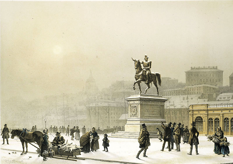 |
| Karl Johan's Square and statue according to Billmark, 1880 (1). |
The lock at Slussen was rebuilt again in the 1930's, creating the car-centric, unpleasant junction that plagued central Stockholm for almost a century. But Slussen is currently under reconstruction again and will hopefully become a more pedestrian-friendly area once again. I will write about these developments in a future post.
 |
| The Slussen area is currently undergoing its customary, once-a-century revamp. |
Railroads
 |
| Red=Railroad today. Orange=Original trunk line from the south. |
The advent of the railroad was probably Stockholm’s biggest and most important infrastructure transformation during the 1800’s, but I have already described this process in detail in my post “The Railroad Comes to Stockholm.” This infrastructure development was not an initiative of the city but was instead financed and planned by the national government.

Horse-Drawn Trams
Horse-drawn omnibuses following set routes and timetables appeared in Stockholm in 1835. The omnibus network expanded through the 1850’s but it was never an economic success. Horses and their upkeep were expensive, especially in a climate like Sweden’s and with steep topography like Södermalm’s, but I also suspect that the lack of a middle class was also a major factor—the countless poor couldn’t afford the omnibuses, most of the wealthier class relied either on private carriages or on taxi services, and there were very few people somewhere in the middle to support public transportation. By 1870, there was only one omnibus line in operation.
In 1870, a private company applied for permission to build up a network of four horse-drawn trams in Stockholm. While horses were still expensive, the rails would make pulling the carriages significantly easier, greatly prolonging the life expectancy of the horses. None of the proposed lines extended to Kungsholmen or Södermalm; these areas were still too poor and the terrain too steep to support public transportation. The company was granted permission but went bankrupt before the tram network was in operation. Several years passed without progress and when Oslo opened a tram line before Stockholm, the city felt that it had to take matters into its own hands. A central committee worked out a new proposal including the original four lines plus three additional ones, still none on Södermalm, and invited private companies to bid on a contract.
In 1877, Stockholm’s first horse-drawn trams were in operation. The lines were serviced with ten-minute traffic and had no official stops; passengers just waved at the conductor to be let on and off. There was only one track, so carriages had to wait for each other at passing places with two tracks. In the winter, the tram cars were replaced with sleds which followed the same routes.
The tram network was expanded and modernized over the next few decades. Official stops kept trams running on schedule, double tracks meant that traffic could move more swiftly and efficiently, and the first electric line was opened as a trial in 1894. The network expanded past the city limits and to the island of Södermalm. Traffic on Södermalm was made possible by steam-powered trams which could navigate the steep terrain up from Slussen. Because of the required change between horse-drawn to steam-powered trams, passengers travelling past Slussen had to change trams at Södermalmstorget (Slussen). By 1899, it was decided that the entire network was to be electrified, and this was carried out in stages until 1905.
 |
| Stockholm's Horse-drawn tram lines, 1877-1905 (4) |
Swamp Drainage
 |
| From north to south and west to east: Träsket, Klara, Nybroviken, Zinkensdamm, Fatburen |
An infrastructure project closely related to quays was the drainage of urban swamps. Areas such as Fatburen Lake, Zinkensdamm Lake, Klara Lake, Nybroviken Harbor, and Träsket (“the swamp”) had once been living ecosystems with clean water and fish populations, but their urban locations as well as the geological process of rising land meant that over the centuries these bodies of water were no longer connected to their original outlets. The bodies of water continually shrunk as residents dumped centuries’ worth of rubbish and sewage into them. They became swampy sewage reservoirs, causing foul odors, epidemics of sickness, and malaria.
While local residents had lobbied for these foul bodies of water to be filled in for a century or more, the city had little willpower or funding to do so. In the case of Fatburen and Zinkensdamm, it wasn’t until the advent of the railroad and Stockholm Southern Station that they were filled in. Klara Lake was never completely filled in, but it was greatly reduced with the construction of the railroad and Stockholm Northern Station. Nybroviken was filled in after the King stepped in and decreed that it should be done. Träsket was filled in in the early 1880’s with left-over stone from the dynamiting of nearby areas.
While local residents had lobbied for these foul bodies of water to be filled in for a century or more, the city had little willpower or funding to do so. In the case of Fatburen and Zinkensdamm, it wasn’t until the advent of the railroad and Stockholm Southern Station that they were filled in. Klara Lake was never completely filled in, but it was greatly reduced with the construction of the railroad and Stockholm Northern Station. Nybroviken was filled in after the King stepped in and decreed that it should be done. Träsket was filled in in the early 1880’s with left-over stone from the dynamiting of nearby areas.
 |
| Medborgarplatsen was once Lake Fatburen |
The draining of Isbladskärret on Djurgården was a different case since this swampy area was too far out of town to have served as an urban trash and sewage dump. Instead, King Karl XIV Johan had the swamp drained through the construction of the canal at Djurgårdsbrunn in order to prevent the breeding of malaria-carrying mosquitoes near his new summer palace at Rosendal.
 |
| Isbladskärret was drained in the 1800's but in an effort to restore the valuable bird nesting site, the city has stopped pumping water out of the wetland. |
Street Lighting
Stockholm’s oldest known ordinance dealing with street lighting is from 1697, immediately following the fire that destroyed the Royal Castle. Lanterns were to be hung on building facades on the island of Riddarholmen (where the royal family moved after the castle burned down) and it was now illegal to carry burning torches through Riddarholmen’s streets. An ordinance from 1747 decreed that lanterns were to be hung on the facade outside of all pubs. In 1749, it was decreed that all property owners were obliged to hang a lantern on their building facade, maintain it, and light it in the evening. At the same time, the city bought 97 lanterns to be hung up in public places and on bridges. Because of Stockholm’s white nights, the lanterns were only to be lit from September through March. If, according to the almanac, the evening was to be moonlit, the lanterns were not to be lit at all. The lanterns were to be put out by 1 a.m. at the latest, and this was checked by wandering night watchmen.
 |
| Jean Cary, 1843 (3). Here, we can see that the street lantern is not lit because the night was supposed to be lit by moonshine according to the almanac. Clouds partially obstructed the moonshine that night, so those out after dark have to carry their own lanterns to light their way. |
The required street lanterns gave off a decidedly weak light. They were nicknamed “wolf eyes” because they were small, glowing light sources that didn’t cast any light on the ground. These wolf eyes were spaced about 60 feet apart and didn’t really make the streets any safer. When going out at night, most people carried their own lanterns with them. The wealthier strata had servants that followed them around bearing lanterns. These perambulating lanterns helped people not to trip on the uneven streets, but they did nothing to prevent thieves from hiding in the darkness. Lantern technology progressed with reflectors and such, but the overall lighting levels didn’t really improve until natural gas entered the scene.
 |
| Elias Martin's painting from 1790 shows a man on a ladder adding oil to and polishing the glass of one of Stockholm's 97 publically-operated lanterns (5). |
In 1853, a private company received permission to build a gasworks near the shore of Klara Canal. While the gasworks was a private initiative, the city now provided the street lights and hired lantern-lighters so individual property owners were excused from the responsibility of keeping their own lanterns lit. By 1859, the network of gas lines and gas-powered street lights extended across most of the city although the poorest, most distant areas didn’t receive gas street lights until the 1920’s.
 |
| Herman Lindqvist's 1904 painting showing gas street lighting on Hamngatan (3). |
The gaslights ushered a new era into Stockholm. Until gas street lighting, the streets were so quiet by 10 p.m. that not a few foreign visitors commented in their journals. But the comparatively bright gas lights made the evening hours accessible to the general public, and a it became common to stroll through the city streets of an evening, to partake in cafe culture, and to attend cultural performances. Most of that which is associated with big city life was not possible until gas street lighting.
 |
| Alf Wallender, 1890, showing Bern's, a popular cafe, and its gaslights (3). |
In 1884, the city took over the production and distribution of natural gas. The gasworks was moved out of the city center when Stockholm Central Station was built and the Klara gasworks area was needed for new railroad tracks.
Water
 |
| The large red building to the south is today's Eriksdalsbadet, the Eriksdal natatorium, which was the original site of the Skanstull and Eriksdal waterworks. The water to the south of Eriksdal is Årstaviken Bay, the waterwork's original water source. The smaller dot to the north is Vanadislunden's water reservoir. The red square to the west is the approximate location of the water reservoir at Stadshagen. The red square to the south is today's Södersjukhuset hospital and the former site of Årstalunden's water reservoir. |
The technology for water mains had advanced long before Stockholm developed a public system; Stockholm was in fact one of Europe’s last major cities to develop a public water system. One of the main hindrances had been the street system—it only became possible for the city to lay waterlines, sewage pipes, and drainage pipes once the city took over street paving and maintenance from private property owners.
Several proposals over several decades were drawn up, discussed, and discarded as too expensive before agreement was reached. Some of the central debates included if the water system should be built up and maintained by the city or by a private company, how far the water mains should extend, where the water for the system should be gathered, and if sewage pipes should be laid while the streets were already torn up in order to lay the water mains. It was eventually decided that the system should be built and run by the city so that a profit-driven company didn’t skip over the poorer areas of town. The city’s coffers didn’t run very deep, so out of necessity, the water system started out small and was subsequently built out with its own profit. Due to the cost (and a lack of foresight), simultaneously building out a sewage system was deemed unnecessary.
Ideally, the city realized that it should take water from a source way outside of the city’s limits. But the cost of piping the water such a distance was deemed too great and Leionacker’s proposal for taking water from Årstaviken, just south of Södermalm, was accepted. A waterworks for cleaning the water through a series of filter pools was built at Årstaviken’s edge at Skanstull and a reservoir was built on top of the hill at Årstalunden, today the hospital Södersjukhuset. From there, 30 kilometers of water mains were built connecting the waterworks to much of the city. The system was in operation by 1861.
 |
| Årstaviken just south of the waterworks |
The city’s water system continued to expand throughout the 1800’s and by the 1880’s, the original waterworks couldn’t keep up with the demand. A new waterworks at Eriksdal was built very close to the original Skanstull waterworks.
 |
| Stockholm's water mains (7). Blue=mains laid by 1861. Red=mains laid 1861-1870. Green=mains laid 1871-1896. North is to the left in this image. |
The majority of new apartment buildings were being built in Norrmalm, quite a distance from the reservoir at Årstalunden, so a new reservoir designed by Gustaf Améen was built atop the hill at Vanadislunden in 1879.
 |
| Drawing from 1879 showing the water reservoir at Vanadislunden (1) |
This reservoir was expanded in 1910, but the castle-like exterior walls were kept intact; the reservoir is still in use today.
 |
| The water reservoir at Vanadislunden. |
An underground reservoir was built at Stadshagen on Kungsholmen in 1895, but it was demolished in the 1930’s. I am not 100% sure but I believe that the reservoir was in the same location as what is today an underground parking garage.
In 1896, a water tower (reservoir and pump station) was built on Södermalm. It was designed by Ferdinand Boberg and also has a medieval military-inspired design.
In 1896, a water tower (reservoir and pump station) was built on Södermalm. It was designed by Ferdinand Boberg and also has a medieval military-inspired design.
 |
| Boberg's drawing for Mosebacke water tower (1) |
The Mosebacke water tower is still a landmark, but it no longer serves its original purpose. Instead, it has been renovated into jealousy-inducing apartments!
 |
| Mosebacke water towe |
The city was quite aware that the continuing rise of industry around the Årsta bay threatened water quality, so the city bought up a lot of the surrounding land and even financed the move of a large slaughter house. Eventually, a gigantic new waterworks was built in a much cleaner location well outside of the city at Norsborg in 1904; the waterworks at Skanstull and Eriksdal became redundant and were closed. Interestingly, several of the pools at Eriksdal were converted into outdoor swimming pools. The natatorium at Eriksdalsbadet is still in use today.
 |
| Originally, Eriksdalsbadet was comprised only of outdoor pools. Today there is even a large indoor natatorium with several pools. |
Sewage and Drainage
Throughout Stockholm’s history, sewage and drainage was dealt with in the most basic of ways. In the 1500’s, King Gösta declared that Stockholmers were no longer allowed to let waste to stand in the streets; instead, they were required to rinse the streets with water so that the waste ran downhill to the water’s edge. The contents of outhouse buckets were by law supposed to be transported out to farms for use as manure, but all too often the contents ended up in the city’s lakes and harbors. For most of the city’s history, wooden roadside ditches served as drainage pipes leading storm water and miscellaneous waste down to the nearest body of water. This insufficient sewage and waste treatment was already causing problems by the 1600’s, and as I already mentioned, yearly cholera outbreaks were costing thousands of lives throughout the first half of the nineteenth century.
 |
| Drawing of a typical covered drainage ditch (7) |
Leijonacker understood that the laying of water mains was the perfect opportunity to develop a sewage and drainage system in Stockholm, and he drew up a proposal for a drainage system covering Norrmalm and Ladugårdslandet (Östermalm) in 1866. The city rejected the proposal and its costs, but by 1872, several limited sections of drainage pipes were built. Several more sections were built out by 1897, but all of these pipes just led the waste away from the streets and into the waterways; the waste was not treated in any way.
 |
| Leijonacker's rejected sewage and drainage plan |
The drainage pipes were not dimensioned to handle household sewage. Instead of dealing with the raw sewage, the city tried to stem the problem of overflowing drainage pipes by forbidding the use of communal water in the flushing of sewage into the communal drainage system. The city hoped to contain sewage to outhouse buckets to be shipped away to the countryside and thus completely outlawed modern toilets. Eventually toilets were allowed if the resulting sewage was treated on-site in septic tanks. This was like the city burying its head in the sand; even before the invention of toilets, there had been a huge problem with people illegally dumping their latrines into open water by the cover of night. In 1904, the installation of toilets was finally allowed, but the sewage was still not treated in any way.
By 1909, the city’s waterways were so toxic that the city understood that it had to develop a better system. But again, instead of treating the sewage, it was decided that it would be transported to the saltwater side of the city and dumped, untreated, into the Baltic Sea. This was decidedly an improvement for the city’s freshwater bodies, but conditions rapidly deteriorated in the city’s harbors and along popular seaside promenades. By 1932, the city had to outlaw swimming in open water. In the 1930’s, the city finally began work on its first sewage treatment plant but it wasn’t until the late 1970’s that the city’s beautiful bodies of water were clean enough for swimming.
Elevators
 |
| From west to east: Mariahissen, Katarinahissen, Stadsgårdshissen |
The topographical divide was only reinforced when public transportation in the way of trams were introduced in the city. As I mentioned above, Södermalm was the last area to receive a tram line. This deficiency was partly relieved by the Katarina Elevator, or Katarinahissen, a private initiative which opened in 1883 and made the 38 meter (125 feet) height difference easy to navigate. Even when Södermalm’s first tram line opened in 1887, the elevator continued to have a place in the public transportation system because a ticket to ride the elevator up was half the cost as taking the tram. The Katarina Elevator was rebuilt in the 1930’s in the original location. It was in operation until recently.
 |
| The elevator and the view from the top. |
A second elevator, Mariahissen, connected the southern shore of Riddarfjärden and Lake Mälaren’s steamboats with the Maria Parish and opened in 1887. It was designed by architect Gustaf Dahl for a private investor. The elevator’s useful life was unfortunately limited, and it was closed in 1937.
 |
| The Maria Elevator is housed in a beautiful brick building on the water's edge. The elevator actually rises higher than the cliff edge and an iron bridge extends out from the elevator to the highest point in the Maria area. |
A third elevator, this time connecting the Katarina Parish with the Baltic quay at Stadsgården, was built in 1907. It was in private operation until 1971.
 |
| Stadsgård's Elevator |
Parks
 |
| From west to east: Strömparterren, Kungsträdgården, Berzelii Parks |
 |
| Kungsträdgården |
The first half of the 1800’s saw the establishment of three centrally-located public parks: the general public was finally granted access to Kungsträdgården, Strömparterren opened in 1832, and Berzelii Park opened in 1858. It is worth noting that all of these parks are most conveniently reached from Norrmalm’s neighborhoods; the poorest residents, living on Södermalm, had quite a walk to reach these parks. Public parks were more-or-less built for the middle class, as public salons. The parks were more than just a green breathing space in an urban environment: they were places of entertainment with music pavilions, cafés, and dance halls.
 |
| Strömparterren Park |
It is also worth noting that the city had far from altruistic motives in establishing these parks—Strömparterren replaced a messy, smelly fishing harbor within view of the Royal Castle, and Berzelii replaced a stinking swamp. None-the-less, these parks provided much needed green spaces in a city growing more dense by the decade, and they established an important precedent for the insertion of parks into future city expansions.
 |
| Berzelii Park |
Conclusion
One interesting aspect of the development of modern infrastructure in Stockholm was the interplay between public and private enterprises. How much should be developed by private companies for profit, and how much should be developed by the city for the good of the population? The balance shifted back and forth, with just about every piece being private at one time and public at another. Railroads were originally built by local, private initiatives, but when that failed, the state took over on a massive, country-wide scale. Private tram initiatives failed, but it was ultimately other private companies that made a success of them. Elevators were never seen as so important that the city had a fundamental stake in ensuring that they were developed, and it was private companies that built and ran them. Street paving was the responsibility of individual property owners, but that method failed spectacularly for hundreds of years before the city took over that burden. Natural gas lines were initially private, but the city quickly took over. Water and sewage was ultimately understood to be too fundamental to risk the whims of private, profit-seeking companies. The appropriate balance of public service and profit-seeking enterprise is still one of Sweden's biggest political debates today.
Within the course of about thirty years, Stockholm developed from a city of cow paths to a clean(er), modern city with railroads, paved streets, street lighting, impressive harbors, and city parks. Stockholm was no longer a polluted backwater; instead, it was poised to become one of Europe’s most beautiful and technologically advanced cities. The development of city infrastructure in the mid 1800’s laid the groundwork for Stockholm’s unprecedented expansion around the turn of the century. Especially important was the idea that the city now took responsibility for its own development and planning—in the years around the 1860’s and 70’s, Stockholm’s planners would redesign the city into a world-class capitol of neighborhoods, boulevards, and parks.
Sources:
Arne Dufwa, Trafik, broar, tunnelbanor, gator (1986)
Thor Richter, Slussen Då, nu...och sedan? (2011)
Ulf Sörenson, editor, Slussen vid Söderström (2004)
Jan Garnert, Stockholmsnatt (1998)
Thomas Lange, editor, Stockholm på spåret (1998)
Anders Cronström, Vattenförsörning och avlopp (1986)
Peter Lundevall, Stockholm den planerade staden (2006)
Thomas Hall, Huvudstad i omvandling (2002)
Thomas Hall, Stockholm’s Annual Rings (1988)
Thomas Hall, Stockholm: The Making of a Metropolis (2009)
Thomas Hall and Katarina Dunér, editors, Den Svenska Staden (1997)
https://sv.wikipedia.org/wiki/Mariahissen
https://sv.wikipedia.org/wiki/Stadsg%C3%A5rdshissen
Images:
All of the images are my own except
(1) Various Wikipedia entries
(2) Ulf Sörenson, editor, Slussen vid Söderström (2004)
(4) Thomas Lange, editor, Stockholm på spåret (1998)
(6) Arne Dufwa, Trafik, broar, tunnelbanor, gator (1986)
(7) Anders Cronström, Vattenförsörning och avlopp (1986)
No comments:
Post a Comment