
A quick recap on the planning saga of Stockholm through the later half of the nineteenth century: First, the city dithered for several decades about the need to plan at all. Finally, the King stepped in and mandated that Stockholm needed a plan, and while he was at it, he had a few suggestions.
The first comprehensive plan was drawn up by Wallström and Rudberg in 1864, but just about everyone found it unrealistic and lacking, even if there were a few ideas that would be incorporated into later plans and eventually even built.
The Lindhagen Plan was published in 1866 and was a vast improvement over the previous plan. The plan featured a hierarchy of streets with a number of wide, tree-lined esplanades and boulevards whisking across the city. Parks and water views were the most common sight line from the boulevard system, and Lindhagen’s plan designated sites for a number of new parks in addition to designating the entire waterfront as public quaysides.
The city then dillydallied about making a decision on the plan for eight more years. In the meantime, the King’s frustration with Stockholm evidently continued as the National Building Code of 1874 required all Swedish cities to draw up comprehensive plans. No development was allowed to occur without a comprehensive plan.
In the mean time, while the city council remained deadlocked about a plan for the city’s future growth, Stockholm was in the middle of its most intense period of population growth, ever. In the 1880’s alone, the city’s population grew by 46%. The population boom of course resulted in a severe housing shortage—the city was literally surrounded by vast tent encampments and ramshackle slums and inside the city, workers crowded into tiny apartments. Living conditions in Stockholm were nearly the worst in Europe, second only to Finland which at that point in time was Russia’s fiefdom. It was critical that Stockholm get its act together and make a plan so that development could restart, alleviating the housing shortage.
Eventually, the plan was broken down into four geographical areas (Östermalm, Norrmalm, Kungsholmen, and Södermalm) in order to make the process a bit more manageable. However, the city was unable to come to a consensus even upon the four smaller geographic areas and debates and counter arguments raged for years. In the end, the city began voting on the plans street for street, sometimes even block by block. In doing so, many of Lindhagen’s big-picture concepts were lost. In 1884, Östermalm was the first plan to be ratified, but only after eighteen years of proposals, counter-proposals, debates, and politicking.
The next plan was Norrmalm. The subject of this post is not about the entire Norrmalm plan—like the nineteenth-century planers, I’ve been a little overwhelmed trying to understand the entire area in one fell swoop. This time my focus is on two north-south thoroughfares: first, the boundary boulevard between the Östermalm and Norrmalm neighborhoods which is today known as Birger Jarlsgatan (Birger Jarl was the almost mythic founder of Stockholm in the 1200’s, and gata = street ) and second, a boulevard that is only a few blocks west which is today known as Sveavägen (Svea ≈ Mother Sweden and vägen = road).

Birger Jarlsgatan is located at the junction between the differently angled street grids of Östermalm and Norrmalm. Before development, a filthy creek called Träskrännilen ran through this low area. Replacing this stinking, disease-spreading creek with a new thoroughfare was one of the King’s ten original requirements for Stockholm’s comprehensive plan. Even so, the location of this boulevard was the single most contentious issue in the Norrmalm plan.
While not as explicitly described as Birger Jarlsgatan, Sveavägen as a “sufficient and appropriate traffic route from the periphery to the center of the city” was also one of the King’s ten original requirements for Stockholm’s comprehensive plan. Being in the middle of Norrmalm and thus entirely within one street grid, Sveavägen is not as dynamic as Birger Jarlsgatan. While the boulevard’s location was not contentious, its width and symbolic grandeur were issues that were debated for years.
Today, the two streets are somewhat similar in scale, but they have completely different vibes. While they had slightly different journeys through the protracted planning process, I do not believe that it was the varying heat of the planning crucible that formed their differing characters. Instead, my observation is that geography plays a much larger role.
Birger Jarlsgatan: The Debate
Just as it took years of counter-proposals and debates for the plan for Östermalm to be ratified, a similarly drawn-out debate raged all through the 1870’s regarding the fates of Sturegatan and Birger Jarlsgatan. Sturegatan was a relatively new street developed on the east side of Humlegården park, and Östermalm’s real estate developers felt that there was money to be won if Sturegatan was extended to the city center and to the Norrmalmstorg Square. The city-engineer faction, hoping to save money, wanted to instead broaden the existing Roslagsgatan. The planning faction, including Lindhagen, advocated that an entirely new and arrow-straight “main street” be built from the bay at Brunnsviken to the bay at Nybroviken. In the end, a new thoroughfare was built, but it was far from the arrow-straight boulevard that Lindhagen had envisioned.
 |
| Birger Jarlsgatan in Lindhagen's original proposal from 1866 (1) |
The developer’s proposal where Sturegatan would become the new thoroughfare involved six different links with two 90-degree changes of direction, and the six links all had different street widths. It was in no way an efficient or direct thoroughfare, and it did not fulfill the King’s express wishes to fill the polluted creek with a new boulevard. Even so, the developers, many of whom sat in the city council, were a strong faction and in the end, their absurd proposal lost by only one vote.
 |
| The developers' proposal from 1876. Red = "thoroughfare." Yellow = Sturegatan. Orange = Norrmalmstorg. (1) |
No one other than the city engineer or the budget office seemed to like the proposal to widen an already existing street instead of building a new thoroughfare—this proposal doesn’t seem to have even made it to the city council’s votes.
In contrast to the developer’s proposal, Lindhagen’s proposal consisted of one straight, continuous thoroughfare. Lindhagen envisioned the street as part of the city’s lungs, allowing polluted air to swiftly sweep up the thoroughfare and out of the city. He also considered the boulevard to be part of the city’s continuous park system, and his planned route was important to connect various green areas—this is one aspect of Lindhagen’s overarching plan that was lost in breaking up the comprehensive city plan into separate neighborhoods and indeed into separate streets or even blocks. The developers hated Lindhagen’s proposal because in knitting together two different street grids, a lot of lots would have obtuse or even worse, sharp angles. Such lots are not as efficient and they are a bit more difficult to build than a normal, right-angled lot. In all of the debates, Lindhagen never seems to have pressed the point that his proposal was most like the straight, ditch-filling street called for by the King. I wonder why this trump card was never used?
 |
| Lindhagen's counter proposal from 1876 (1) |
 |
| The city's counter counter proposal from 1877 (1) |
 |
| Lindhagen's counter counter counter proposal from 1877 (1) |
 |
| The developers' counter counter counter counter proposal from 1877. Red = "thoroughfare." Yellow = Sturegatan. Orange = Norrmalmstorg. (1) |
There was no consensus on the boulevard, and the debate raged back and forth between the developer’s Sturegatan plan and Lindhagen’s arrow-straight plan for years. As the decision moved up the various layers of city bureaucracy, the “winner” was sometimes the Sturegatan plan, sometimes Lindhagen’s plan. After a few years of debate, the street was broken up into three separate decisions put up to vote in 1877: the northern end, the middle, and the southern end.
First on the agenda seems to have been the middle section of the street from Rådmansgatan to Engelbrektsplan. Here, Lindhagen’s proposal won out with a large majority of the vote. The same was true for the northern end of the boulevard. But the southern end, which was the last to be decided, was a very close call and Lindhagen’s proposal won out by only one vote. A change of only one vote would have resulted in a completely different downtown Stockholm than what exists today.
While Lindhagen’s proposal more-or-less won out, breaking up the street into three different decisions resulted in a crooked path. The winning variation is certainly not as complicated as the developer’s proposal, but it is far from the symbolic, arrow-straight boulevard that Lindhagen had first envisioned. Additionally, Lindhagen’s boulevard was reduced in width and is considerably less green than the original proposal. While Birger Jarlsgatan is tree lined today, it can be hardly considered to be part of Stockholm’s park system.
 |
| The city's final proposal from 1878. Today's Birger Jarlsgatan is pretty close to this proposal. (1) |
As a bit of a consolation prize for the developers, it was then decided that Sturegatan would be extended down to meet the new Birger Jarlsgatan at an open square. The developers got their connection to downtown after all, albeit not in the way they had proposed.
The King ratified these decisions in 1879, but actual construction of the boulevard wouldn’t begin until 1898.
Birger Jarlsgatan: Result
Birger Jarlsgatan was developed at a time when Sweden’s economic growth was unparalleled and Stockholm became a modern and international city. The boulevard became a symbol for all of Sweden for this newfound wealth and modernity. Even today, the street name Birger Jarlsgatan is known throughout Sweden and is associated with the big city, big business, and shopping. The street is home to many company headquarters and banking offices, and it is also the only place in Stockholm (and probably all of Sweden?) where the likes of Chanel, Gucci, and Burberry can be procured in flagship stores.

Birger Jarlsgatan’s development as a shopping mecca and base for corporate headquarters had a big impact on the boulevard’s architecture. Sweden’s first large display windows and its first solely commercial building are to be found along the boulevard.
 |
| Right: Sweden's first all-commercial building |
From the beginning, the Birger Jarlsgatan address was so important and coveted that developers paid extra attention to the architecture along the street. Soon, the boulevard was lined with Classical temples, Venetian palaces, and Loire Valley castles.


Birger Jarlsgatan’s path knitting together two differing street grids resulted not only in towers but also in many “left over” spots. Many of these have become squares and pocket parks, giving the boulevard an even more dignified aura. Some of these “left overs” are under-designed and under-utilized, but the airy, grand environment remains.

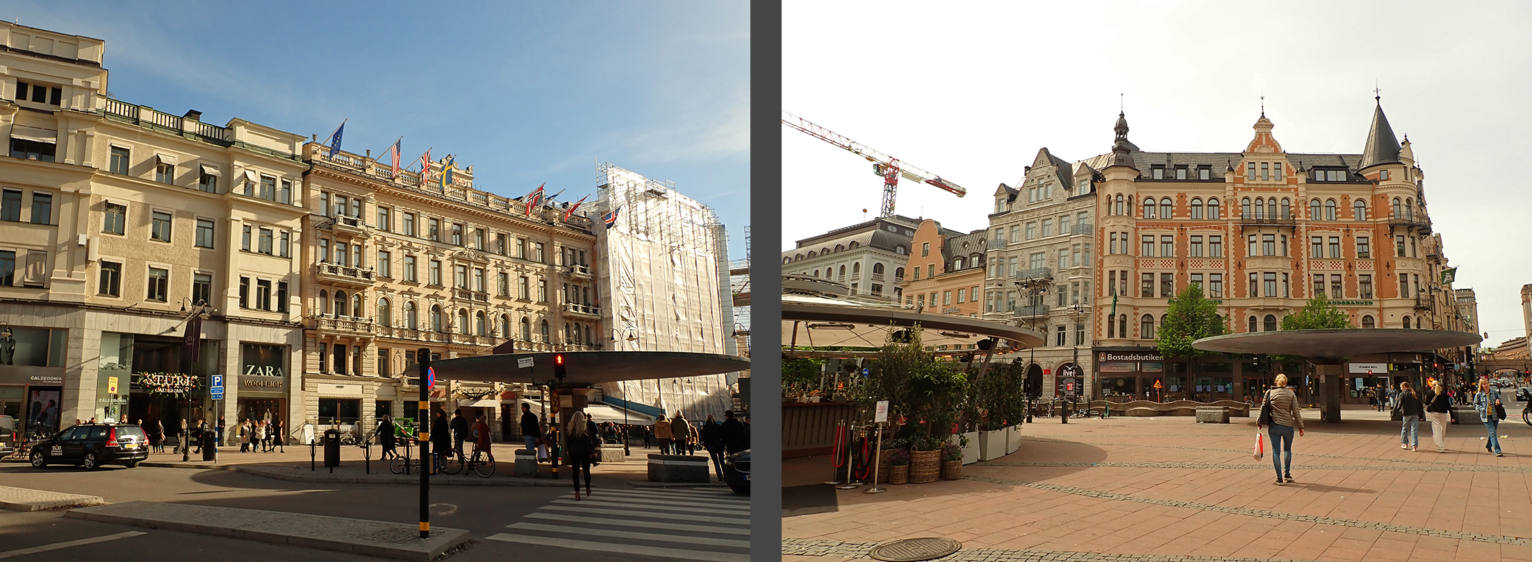
The southern end of the boulevard is much fancier that the northern end. The southern end is in the city center and features the important headquarters and designer shopping. The northern end is much more residential in nature, but even the geography here results in a less grand impression because to the north, the street is lined by regular city blocks and has right-angled street junctions. The lack of sharply angled lots and left-over spaces makes the northern end of the boulevard much more ordinary than the stimulating southern end.

Birger Jarlsgatan begins at the southern end at the water at Nybroviken Bay, but it does not extend to the bay at Brunnsviken as originally envisioned by Lindhagen. Instead, it peters out at a lackluster, could-be-anywhere roundabout known as Roslagstull (originally the site of one of the city’s Toll Houses) where an expressway leads out into the burbs. Looking at older maps, one can see that Brunnsviken Bay used to extend farther south and was originally within sight of the end of Birger Jarlsgatan, but it has since been filled in to provide space for the suburban motorway.

Sveavägen: The Debate
In 1654, architect Jean de la Vallée presented a plan which called for an axial parade avenue from the Royal Palace Slottet, over the water, through Gustav Adolf’s Torg, and through Norrmalm all the way to the water at Brunnsviken.

 |
| Jean de la Vallées vision in a modern rendering (2) |
Jean de la Vallée’s idea of a formal, axial avenue stretching from the palace to the water’s edge at Brunnsviken was reimagined in the Lindhagen Plan of 1866. Heavily influenced by Haussmann’s Parisian boulevards, this new Sveavägen was monumental in scale at 240 feet (70m) wide, and it dominated the entire cityscape. The avenue was to have lanes of traffic on either side of two planted allées of trees which were to be separated by a carriageway for leisurely strolls and rides. Sveavägen was to be as wide as Champs-Élysées in Paris, and it would have been one of the 19th century’s most ambitious projects in all of Europe. While the northern end was on low-lying and mostly undeveloped land, the southern end would demolish the high Brunkeberg Ridge


and the market square Hötorget

 |
| Sveavägen in Lindhagen's original proposal from 1866. Red = Sveavägen. Yellow = Adolf Fredrik’s Church. Blue = Hötorget. Orange = Stockholm's Castle Slottet (1) |
This boulevard was never built as envisioned—while Sveavägen does cut through much of Stockholm today, it doesn’t reach all the way to Gustav Adolf’s Torg or to the Royal Palace and the boulevard is definitely not as wide as originally designed. Like Birger Jarlsgatan, much of the original intention was lost in the political planning process.
 |
| The city's proposal from1876. Red = Sveavägen. Yellow = Adolf Fredrik’s Church. Orange = Stockholm's Castle Slottet (1) |
Given the massive critique that his original Sveavägen plan had generated, when the planning process was again underway, Lindhagen drew up a much less ambitious plan in 1876. In this new proposal, Sveavägen would now end at a new east-west boulevard (today Odengatan) and would not continue into built-up areas further south. This 1876 plan does retain, however, Lindhagen’s ambitious street with of 70m.
 |
| Lindhagen's counter proposal from 1876. Red = Sveavägen. Yellow = Adolf Fredrik’s Church. Orange = Stockholm's Castle Slottet (1) |
In 1877, the city council countered with a plan that was simultaneously more and less ambitious than Lindhagen’s 1876 proposal. This proposal continues Sveavägen a few blocks further south than Lindhagen’s plan, cutting through several built-up blocks. Sveavägen would end at Adolf Fredrik’s Church. Because this proposal was much reduced in width and was only 48m wide, the church would not be demolished, but the churchyard would be diminished.
 |
| The city's counter counter proposal from 1877. Red = Sveavägen. Yellow = Adolf Fredrik’s Church. Orange = Stockholm's Castle Slottet (1) |
That same year, Lindhagen countered again. If the avenue was going to continue through developed blocks and then stop at the church, it should stop just short of the church so that the greenery of the churchyard could serve as the avenue’s focal point. Lindhagen continued to show a 70m wide avenue with two planted allées and three roadbeds. He bemoaned the city council’s stingy street width writing that the city ordinance called for esplanades with at least one allée in the middle, and 48m was not wide enough for an allée. Furthermore, because Sveavägen was going to become Stockholm’s most important thoroughfare connecting the heart of the city with the green areas and suburbs beyond, it should be even wider and grander than the “average” esplanade. He pointed out that his proposed avenue was less wide than the new boulevard in provincial Gävle to the north as well as new boulevards in three provincial cities in Finland. It is clear that Lindhagen considered Sveavägen to be part of his park system and that he considered this boulevard to be even more important than Birger Jarlsgatan.
 |
| Lindhagen's counter counter counter proposal from 1877. Red = Sveavägen. Yellow = Adolf Fredrik’s Church. (1) |
The city council was not moved by Lindhagen’s arguments. Instead, they produced a new counter-proposal which was much like their previous proposal except that it now extended even farther south into the city center. They argued that a few more blocks of existing development would have to be sacrificed in order to connect the new areas to the older areas of the city, and to achieve a functional traffic flow. For once the suburban commuters arrived in the city, where would they go? In this proposal, Sveavägen would connect to a new east-west thoroughfare which would connect the market at Hötorget through a tunnel to through the Brunkeberg Ridge with the Engelbreksplan Square on Birger Jarlsgatan and the park at Humlegården.
 |
| The city's counter counter counter counter proposal from 1877. Red = Sveavägen. Brown = new street and tunnel between Hötorget (blue) and Humlegården park (green) (1) |
Later that same year, the city council reversed itself and came to the conclusion that the existing network of streets could handle the additional traffic that would be coming into the city via Sveavägen. Their new counter-proposal was to stop the new boulevard at the church, not cutting through the church yard as Lindhagen had proposed. However, the city council remained firm that the boulevard shouldn’t be any wider than 48m.
 |
| The city's counter counter counter counter proposal from 1877. Red = Sveavägen. Yellow = Adolf Fredrik’s Church. (1) |
While there was some back-and-forth, Sveavägen was not as contentious as Birger Jarlsgatan. Everyone was reasonably in agreement about the street placement and route, but not about the width. The street placement and route was voted on first and the majority voted for the most recent proposal (where the council and Lindhagen had been unified that Sveavägen would stop just short of the churchyard). There was a separate vote about Sveavägen’s width, and only two votes were cast for Lindhagen’s ambitious avenue. It was decided that the boulevard would be 48m wide, meaning that while there would be trees planted along the street edges, there would be no planted allées in the middle.
In 1896, the city council voted to extend Sveavägen to the east-west thoroughfare Kungsgatan at the market square Hötorget. It wasn’t until the 20th century that planners would consider extending the boulevard farther south.
 |
| 1896 Extension of Sveavägen. Light red = existing part of Sveavägen. Red = extension of Sveavägen. Yellow = Adolf Fredrik’s Church. Blue = Hötorget. Brown = Kungsgatan |
Sveavägen: Result and Comparison to Birger Jarlsgatan
Sveavägen is today a very important thoroughfare in Stockholm, and several of Stockholm’s most important institutions were built alongside it in the era of Swedish Grace or Nordic Classicism: the concert hall, the school of business, and the city library.
 |
| The School of Business (Handelshögskolan) and Stockholm City Library |
Strangely, the Concert Hall would be oriented toward Hötorget and had only a backside toward Sveavägen, giving the boulevard a feeling of disregard.
 |
| The Concert Hall. Left: the front facing the Hötorget Square. Right: the back facing Sveavägen |
In addition to the cultural institutions mentioned above, Sveavägen does feature a few of Stockholm’s earliest and most important Modern buildings.


Like Birger Jarlsgatan, the southern end of Sveavägen in the city center is very commercial with offices, stores, and restaurants, but the stores and restaurants are much more local in character than on Birger Jarlsgatan. While Birger Jarlsgatan features Michelin-rated bistros, you’re more likely to find a neighborhood Chinese buffet on Sveavägen. After the Pandemic, Sveavägen even has a couple of empty storefronts which is almost unheard of in Stockholm today.


Lacking angled intersections and the resulting left over spaces, Sveavägen is not dotted by parks and squares in the same way as Birger Jarlsgatan. However, Sveavägen’s overall impession is still relatively green and airy. The street is lined with trees, and there are several gaps in the urban fabric at Adolf Fredrik’s Church, the park at Observatorielunden, and the park at Vanadislunden.


Similar to Birger Jarlsgatan, Sveavägen ends in a tragically boring roundabout where large roads lead out to the suburbs. This roundabout did not feature a tollhouse like Birger Jarlsgatan’s roundabout, but it does coincide with the old toll fence surrounding the city. This anticlimactic termination is far from the beautiful water-and-park view that both Jean de la Vallée and Lindhagen had envisioned. But Lindhagen must have known that Sveavägen wasn’t going to get the idyllic finish he had hoped for—beyond the roundabout is a railroad that was even drawn in on Lindhagen’s plan from 1876. In between the roundabout and the railroad is a “skyscraper” from 1960 which now caps Sveavägen’s axis. It’s unfortunate that this prominent building is not more architecturally interesting as it does nothing to alleviate the unfortunate blandness at Sveavägen’s terminus.

Conclusion
I’m a bit fascinated that two parallel grand boulevards were planned to lead from the bay at Brunnsviken in the north to the Baltic sea to the south, especially since they are only four blocks apart. Today, the streets have roughly the same capacity and fulfill roughly the same purpose. Why the need for two north-south boulevards so close to each other? Part of the answer can be found in Lindhagen’s original plan where the extremely wide Sveavägen was supposed to be THE boulevard of all boulevards. In comparison, Birger Jarlsgatan was merely one of several “regular” boulevards in Lindhagen’s plan.
In Lindhagen’s plan, it was Sveavägen that was supposed to be Stockholm’s iconic boulevard—it was to be as wide as the Champs-Élysées and lead directly to the Royal Palace. Instead, Birger Jarlsgatan usurped that role and is today the better known boulevard due to the iconic businesses and flagship stores that line it, as well as because of the literally towering architecture. While Sveavägen is still important in the Stockholm landscape, it is much more of a traffic thoroughfare, probably because it is so straight and direct a route from the suburbs into the city center.
Interestingly, Birger Jarlsgatan is a “street” and Sveavägen is a “road.” Just like the English “street,” “gata” has connotations of an urban, tightly developed setting. And like the English “road,” “väg” has connotations of a higher speed, suburban thoroughfare. Sveavägen’s feel is far from suburban, but it does feel more like a thoroughfare than Birger Jarlsgatan. Can it be that the city designed these two boulevards to have differing characters from the very beginning?
What made Birger Jarlsgatan the more desirable address? I think that the answer lies in several geographical factors. First, Birger Jarlsgatan lies at the edge of Östermalm which has been Stockholm’s poshest neighborhood since the mid 1800’s. (Sveavägen lies in the middle of Norrmalm which was historically a “regular” neighborhood—not where the wealthiest lived, but not where the poorest lived, either.) Secondly, Birger Jarlsgatan is the natural continuation of Strandvägen, Stockholm’s premier residential address. And thirdly, all of the inefficient, odd angles at the junction of the two street grids that the developers were so against made for iconic architecture and a dynamic urban landscape. Put together, these geographical factors have resulted in a much more symbolically important boulevard than Sveavägen despite original intentions.
Sources:
Gösta Selling, Esplanadsystemet och Albert Lindhagen: Stadsplanering i Stockholm åren 1857-1887 (1970)
Thomas Hall, Stockholm: The Making of a Metropolis (2009)
Thomas Hall, Huvudstad i Omvandling (2002)
Alla Tiders Stockholm (2014)
Peter Lundewall, Stockholm den planerade staden (2006)
Images:
All images are my own except
1) Gösta Selling, Esplanadsystemet och Albert Lindhagen: Stadsplanering i Stockholm åren 1857-1887 (1970)
2) Thomas Hall, Huvudstad i Omvandling (2002)
No comments:
Post a Comment